
Upper Barron
| Upper Barron Queensland | |||||||||||||||
|---|---|---|---|---|---|---|---|---|---|---|---|---|---|---|---|
 Belson Road, Upper Barron | |||||||||||||||
 Upper Barron | |||||||||||||||
| Coordinates | 17°23′20″S 145°30′25″E / 17.3888°S 145.5069°E | ||||||||||||||
| Population | 503 (SAL 2021)[1] | ||||||||||||||
| Postcode(s) | 4883 | ||||||||||||||
| Elevation | 710–1,250 m (2,329–4,101 ft) | ||||||||||||||
| Area | 104.4 km2 (40.3 sq mi) | ||||||||||||||
| Time zone | AEST (UTC+10:00) | ||||||||||||||
| Location | |||||||||||||||
| LGA(s) | Tablelands Region | ||||||||||||||
| State electorate(s) | Hill | ||||||||||||||
| Federal division(s) | Kennedy | ||||||||||||||
| |||||||||||||||
Upper Barron is a rural locality in the Tablelands Region, Queensland, Australia.[2] In the 2021 census, Upper Barron had a population of 503 people.[3]
Geography[edit]

The western part of the locality is higher and mountainous while the central and eastern parts are lower and flatter. The Barron River rises in the south of the locality and flows in a northerly direction towards Wongabel and East Barron.[4]
Upper Barron has the following mountains and mountain passes (from north to south):
- Mount Weerimba (17°22′49″S 145°31′15″E / 17.3802°S 145.5208°E) 902 metres (2,959 ft)[5][6]
- Gum Tree Hill (17°25′27″S 145°29′29″E / 17.4241°S 145.4915°E) 1,037 metres (3,402 ft)[5][7]
- Mount Hypipamee (17°25′35″S 145°29′02″E / 17.4265°S 145.4840°E) 1,030 metres (3,380 ft)[5][8]
- Longland Gap (17°27′50″S 145°29′29″E / 17.4639°S 145.4914°E)[5][9]
All of the western part of the locality is protected, being within one of the Herberton Range National Park, the Herberton Range Conservation Park, or the Mount Hypipamee National Park (17°25′32″S 145°29′10″E / 17.4255°S 145.4861°E).[10] The predominant land use in the rest of the locality is grazing on native vegetation, except in the north of the locality where there is irrigated crop growing, being mostly sugarcane.[4]
The Kennedy Highway enters the locality from the north-west (Wongabel) and exits to the south-west (Evelyn).[4] The Malanda–Atherton Road runs through the northeastern corner.[11]
History[edit]
Upper Barron was previously a locality in both the Shire of Atherton and the Shire of Eacham, both of which were part of the 2008 local government amalgamation which created the Tablelands Region.[2]
Upper Barron State School opened on 31 January 1911.[12] It was mothballed on 31 December 2008 as there were only nine students.[13][14] It closed on 31 December 2009.[15] It was at 9570 Kennedy Highway (17°22′58″S 145°30′52″E / 17.3827°S 145.5145°E).[16][4] The school's website was archived.[17]
Mount Hypipamee National Park (17°25′32″S 145°29′10″E / 17.4255°S 145.4861°E) was established on 16 January 1982.[10]
In the 2016 census, Upper Barron had a population of 451 people.[18]
In the 2021 census, Upper Barron had a population of 503 people.[3]
Education[edit]
There are no schools in Upper Barron. The nearest government primary schools are Malanda State School in neighbouring Malanda to the east, Atherton State School in Atherton to the north, and Yungaburra State School in Yungaburra to the north-east. The nearest government secondary schools are Malanda State High School in Malanda and Atherton State High School in Atheron.[4]
References[edit]
- ^ Australian Bureau of Statistics (28 June 2022). "Upper Barron (suburb and locality)". Australian Census 2021 QuickStats. Retrieved 28 June 2022.
- ^ a b "Upper Barron – locality in Tablelands Region (entry 48912)". Queensland Place Names. Queensland Government. Retrieved 29 December 2020.
- ^ a b Australian Bureau of Statistics (28 June 2022). "Upper Barron (SAL)". 2021 Census QuickStats. Retrieved 28 February 2023.
- ^ a b c d e "Queensland Globe". State of Queensland. Retrieved 29 May 2023.
- ^ a b c d "Mountain peaks and capes - Queensland". Queensland Open Data. Queensland Government. 12 November 2020. Archived from the original on 25 November 2020. Retrieved 25 November 2020.
- ^ "Mount Weerimba – mountain in Tablelands Region (entry 36890)". Queensland Place Names. Queensland Government. Retrieved 25 November 2020.
- ^ "Gum Tree Hill – mountain in Tablelands Region (entry 15018)". Queensland Place Names. Queensland Government. Retrieved 25 November 2020.
- ^ "Mount Hypipamee – mountain in Tablelands Region (entry 16562)". Queensland Place Names. Queensland Government. Retrieved 25 November 2020.
- ^ "Longland Gap – pass in the Tablelands Region (entry 20041)". Queensland Place Names. Queensland Government. Retrieved 29 May 2023.
- ^ a b "Mount Hypipamee National Park – national park, resources reserve, conservation park in Tablelands Regional (entry 23050)". Queensland Place Names. Queensland Government. Retrieved 8 March 2023.
- ^ Google (10 August 2023). "Upper Barron, Queensland" (Map). Google Maps. Google. Retrieved 10 August 2023.
- ^ Queensland Family History Society (2010), Queensland schools past and present (Version 1.01 ed.), Queensland Family History Society, ISBN 978-1-921171-26-0
- ^ "Opening and closing dates of Queensland Schools". Queensland Government. Retrieved 28 January 2021.
- ^ "No reprieve for Upper Barron State School". ABC News. 21 December 2008. Archived from the original on 5 May 2018. Retrieved 28 January 2021.
- ^ "Queensland state school - centre closures" (PDF). Queensland Government. 20 August 2013. Archived (PDF) from the original on 20 March 2022. Retrieved 6 April 2022.
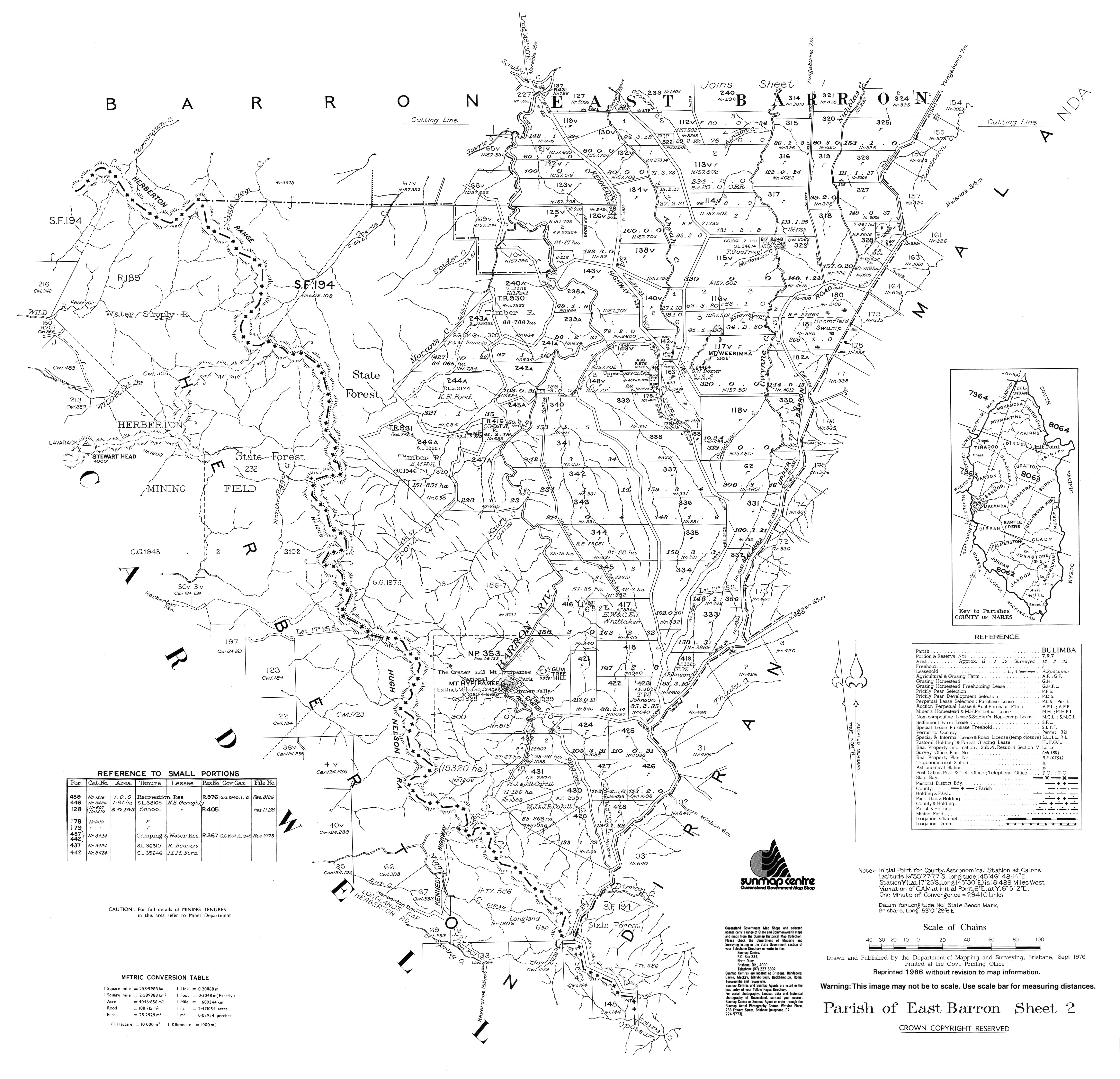
- ^ "Parish of East Barron, Sheet 2" (Map). Queensland Government. 1976. Archived from the original on 13 April 2022. Retrieved 13 April 2022.
- ^ "Welcome to Upper Barron State School: Learning is Living". Upper Barron State School. 10 October 2008. Archived from the original on 10 October 2008. Retrieved 13 April 2022.
- ^ Australian Bureau of Statistics (27 June 2017). "Upper Barron (SSC)". 2016 Census QuickStats. Retrieved 20 October 2018.