Ballyknockan
Ballyknockan
Buaile an Chnocáin | |
|---|---|
Village | |
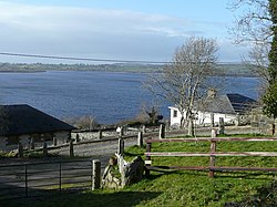
 Ballyknockan overlooks Poulaphouca Reservoir | |
| Coordinates: 53°06′21″N 6°29′52″W / 53.10583°N 6.49778°W | |
| Country | Ireland |
| Province | Leinster |
| County | County Wicklow |
| Population (2016)[1] | 227 |
Ballyknockan or Ballynockan (/bæləˈnɒkən/ bal-ə-NOK-ən; Irish: Buaile an Chnocáin)[2] is a village and townland in County Wicklow, Ireland.
Ballyknockan is situated on the western edge of a large granite band extending from Dublin Bay to County Carlow.[3] Ballyknockan village is located 220 metres above sea level and is around 25 miles from Dublin City Centre.
Ballyknockan hosted KnockanStockan, an independent music festival which was held annually each summer from 2007 until 2019.[4]
Commercial granite quarries were first opened in the early 1820s which lead to the development of the village.[5] Many of the first workers came from nearby Manor Kilbride.[6] According to an Ordnance survey of 1838, at the time almost half of the population of 400 were employed in the quarries.[3]
Ballyknockan was an area of anti-landlord agitation during the Land War. In 1887, a widow and her family were to be evicted from their home. Men employed by her landlord knocked the roof of her house and evicted the family while they were at mass. A law at the time stated that if a house was built within a day with smoke coming out of the chimney, the occupants couldn’t be evicted. The community worked together and built a house in a day for them and the fire was lit, ensuring they could not be evicted.[7][8] A plaque commemorating the event can be seen on the remains of the ruined cottage.[9]
In 1940 the village of Balinahown was completely flooded and parts of the surrounding villages of Valleymount and Lacken were also flooded to make way for the Poulaphouca Reservoir which spans out over 20 km2 across the land. Since then, the village overlooks the reservoir that provides water to thousands of Dublin homes and creates electricity, while also offering many water pursuits such as fishing, sailing, windsurfing, boating, and leisure cruising and canoeing.[10]
See also[edit]
Further reading[edit]
- Wicklow History & Society by Ken Hannigan & William Nolan 1994
References[edit]
- ^ "Ballyknockan (Ireland) Census Town". citypopulation.de. Retrieved 28 March 2020.
- ^ "Buaile an Chnocáin / Ballyknockan". logainm.ie. Irish Placenames Commission. Retrieved 28 March 2020.
- ^ a b "Ballyknocken". County Wicklow Heritage. 20 October 2020. Retrieved 1 June 2021.
- ^ Moran, Fionnuala (10 February 2020). "Sad news as KnockanStockan team decides to end festival after 13 years". Evoke. Retrieved 16 July 2023.
- ^ Ó Maitiú, Séamas; O'Reilly, Barry (1997). Ballyknockan: a Wicklow stonecutters' village. Dublin: Woodfield Press. ISBN 0-9528453-5-0.
- ^ Medcalf, David (1 August 2015). "At the heart of Granite Village". Irish Independent. Retrieved 16 July 2023.
- ^ "Ballyknockan (Bhuaile an Chnocáin) Village". County Wicklow Heritage. 18 March 2020. Retrieved 16 July 2023.
- ^ A House in a Day. Wicklow Heritage. 13 August 2020 – via YouTube.
- ^ "Ballyknockan (Bhuaile an Chnocáin) Village". County Wicklow Heritage. 18 March 2020. Retrieved 16 July 2023.
- ^ "Stone; an illustrated magazine". 24. New York: Frank J. Hoyt. 1902: 324–325.
{{cite journal}}: Cite journal requires|journal=(help)


