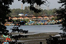
Mappila Bay
This article needs additional citations for verification. (January 2021) |


Mappila Bay (or Moppila Bay) is a natural harbor situated at Ayikkara in Kannur Municipal Corporation, Kerala state of South India.[1] On one side of the bay is Fort St. Angelo, built by the Portuguese in the 15th century and the other side is the Arakkal Palace.
The bay was famous during the Kolathiri's regime as a commercial harbour that linked Kolathunadu with Lakshadweep and foreign countries, in imports.

See also[edit]
Wikimedia Commons has media related to Mappila Bay.
References[edit]
- ^ "Fishing at Mappila Bay kannur : DTPC Kannur". dtpckannur. DTPC Kannur (Dept.of Tourism, Govt. of Kerala). Archived from the original on 23 January 2021.
11°51′24″N 75°22′33″E / 11.856652°N 75.375888°E
