
Mali Zvornik
Mali Zvornik
Мали Зворник (Serbian) | |
|---|---|
Town and municipality | |
     Mali Zvornik | |
 Coat of arms | |
 Location of the municipality of Mali Zvornik within Serbia | |
| Coordinates: 44°24′N 19°07′E / 44.400°N 19.117°E | |
| Country | |
| Region | Šumadija and Western Serbia |
| District | Mačva |
| Municipality | 1955 |
| Settlements | 12 |
| Government | |
| • Mayor | Zoran Jevtić (SNS) |
| Area | |
| • Town | 9.09 km2 (3.51 sq mi) |
| • Municipality | 184 km2 (71 sq mi) |
| Elevation | 149 m (489 ft) |
| Population (2011 census)[2] | |
| • Town | 4,132 |
| • Town density | 450/km2 (1,200/sq mi) |
| • Municipality | 11,987 |
| • Municipality density | 65/km2 (170/sq mi) |
| Time zone | UTC+1 (CET) |
| • Summer (DST) | UTC+2 (CEST) |
| Postal code | 15318 |
| Area code | +381(0)15 |
| Car plates | LO |
| Website | www |
Mali Zvornik (Serbian Cyrillic: Мали Зворник, pronounced [mâːliː zʋɔ̌rniːk]) is a town and municipality located in the Mačva District of western Serbia. In 2011, the population of the town is 4,132, while the population of the municipality is 11,987. It lays on the Drina river opposite of the town of Zvornik, in Bosnia and Herzegovina. Also, a border crossing between Serbia and Bosnia and Herzegovina is located in the town.
History[edit]
There are traces of human life from Bronze Age in this area, as well as traces from the time of Roman Empire. Ancient Roman settlement Ad Drinum existed somewhere at this location. In the Middle Ages, Mali Zvornik was one of the main mining centres of the Serbian state.
On Orlovine Hill near Mali Zvornik there are remains of the large Medieval fortress that was probably built in the first half of the 15th century, in the time of the Serbian Despotate. During the Ottoman rule, this area was part of the Pashaluk of Bosnia.
Until 1878 it was the only Bosnian municipality on the right side of river Drina, when it eventually became part of the independent Kingdom of Serbia. In the end of 19th and beginning of the 20th century, population of Mali Zvornik numbered 115 houses. The municipality of Mali Zvornik was officially established in 1955.
Settlements[edit]
Aside from the town of Mali Zvornik, the municipality includes the following settlements:
Demographics[edit]
| Year | Pop. | ±% p.a. |
|---|---|---|
| 1948 | 9,036 | — |
| 1953 | 12,004 | +5.84% |
| 1961 | 11,583 | −0.45% |
| 1971 | 12,084 | +0.42% |
| 1981 | 13,074 | +0.79% |
| 1991 | 14,029 | +0.71% |
| 2002 | 14,076 | +0.03% |
| 2011 | 12,482 | −1.33% |
| Source: [3] | ||
According to the 2011 census results, the municipality of Mali Zvornik has 12,482 inhabitants.
Ethnic groups[edit]
The municipality of Mali Zvornik has many ethnic groups, with Serbs forming the majority in all settlements. The ethnic composition of the municipality of Mali Zvornik:
| Ethnic group | Population | % |
|---|---|---|
| Serbs | 11,677 | 93.55% |
| Muslims | 376 | 3.01% |
| Bosniaks | 72 | 0.58% |
| Romani | 25 | 0.20% |
| Montenegrins | 16 | 0.13% |
| Yugoslavs | 15 | 0.12% |
| Croats | 14 | 0.11% |
| Others | 287 | 2.30% |
| Total | 12,482 |
Economy[edit]
The following table gives a preview of total number of employed people per their core activity (as of 2017):[4]
| Activity | Total |
|---|---|
| Agriculture, forestry and fishing | 93 |
| Mining | 70 |
| Processing industry | 168 |
| Distribution of power, gas and water | 101 |
| Distribution of water and water waste management | 55 |
| Construction | 114 |
| Wholesale and retail, repair | 319 |
| Traffic, storage and communication | 187 |
| Hotels and restaurants | 70 |
| Media and telecommunications | 8 |
| Finance and insurance | 8 |
| Property stock and charter | - |
| Professional, scientific, innovative and technical activities | 45 |
| Administrative and other services | 18 |
| Administration and social assurance | 326 |
| Education | 177 |
| Healthcare and social work | 112 |
| Art, leisure and recreation | 17 |
| Other services | 29 |
| Total | 1,917 |
Gallery[edit]
-
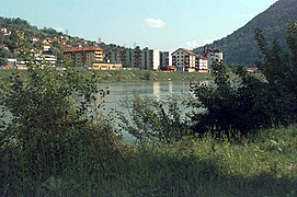 Mali Zvornik
 -
 Mali Zvornik Municipal House
 -
 Mali Zvornik town center
 -
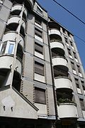 Building in Mali Zvornik
 -
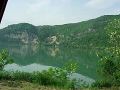 Drina river in Mali Zvornik


Notable people[edit]
- Časlav Klonimirović, Prince of the Serbs from 927. until his death in 960.
- Stefan Dragutin, King of Serbia from 1276. to 1282.
- Avdo Karabegović, (1878-1908) Serbian poet
- Dušan Proroković, politician, former member of Serbian parliament
- Milisav Petković, politician, former member of Serbian parliament
- Nenad Milkić, Serbian writer
- Miloš Gajić, Partisan
- Milinko Pantić, football player and coach
- Miloš Vasić, rower, member of Serbian Olympics team on summer Olympics in London 2012 and Rio de Janeiro 2016
- Predrag Rogan, football coach
- Đorđe Despotović, football player
- Nemanja Stevanović, football player
- Edin Rustemović, football player
- Filip Erić, football player
- Slaviša Radović, football player
- Oliver Stević, basketball player
- Aleksandar Todorović, basketball player
See also[edit]
References[edit]
- ^ "Municipalities of Serbia, 2006". Statistical Office of Serbia. Retrieved 2010-11-28.
- ^ "2011 Census of Population, Households and Dwellings in the Republic of Serbia: Comparative Overview of the Number of Population in 1948, 1953, 1961, 1971, 1981, 1991, 2002 and 2011, Data by settlements" (PDF). Statistical Office of Republic Of Serbia, Belgrade. 2014. ISBN 978-86-6161-109-4. Retrieved 2014-06-27.
- ^ "2011 Census of Population, Households and Dwellings in the Republic of Serbia" (PDF). stat.gov.rs. Statistical Office of the Republic of Serbia. Archived from the original (PDF) on 14 July 2014. Retrieved 29 May 2017.
- ^ "ОПШТИНЕ И РЕГИОНИ У РЕПУБЛИЦИ СРБИЈИ, 2018" (PDF). stat.gov.rs (in Serbian). Statistical Office of the Republic of Serbia. Retrieved 16 March 2019.


