
M41 highway
| M41 highway | |
|---|---|
| Pamir Highway | |
 The historical Pamir Highway travels through Afghanistan, Uzbekistan, Tajikistan and Kyrgyzstan in Central Asia. The modern M41 extends further from Osh to Kara-Balta in the western suburbs of Bishkek | |
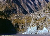
.jpg) Pamir highway from Khargush to Murghab, Tajikistan | |
| Route information | |
| Part of | |
| Length | 1,252 km[1] (778 mi) |
| History | The road formed one link of the ancient Silk Road trade route |
| Location | |
| Countries | Afghanistan, Uzbekistan, Tajikistan, Kyrgyzstan |
| Highway system | |
The M41, known informally and more commonly as the Pamir Highway (Russian: Памирский тракт, romanized: Pamirsky Trakt), is a road traversing the Pamir Mountains through Afghanistan, Uzbekistan, Tajikistan and Kyrgyzstan with a length of over 1,200 km. It is the only continuous route through the difficult terrain of the mountains and is the main supply route to Tajikistan's Gorno-Badakhshan Autonomous Region. The route has been in use for millennia, as there are a limited number of viable routes through the high Pamir Mountains. The road formed one link of the ancient Silk Road trade route. M41 is the Soviet road number, but it only remains as an official designation in post-Soviet Uzbekistan, as confirmed by official decree.[2] Kyrgyzstan[3] and Tajikistan[4] have passed decrees abolishing Soviet numbering of highways and assigning their own national numbering.
Route description[edit]
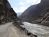
Sources disagree on the termini of the highway, with Mazari Sharif, Afghanistan; Termiz, Uzbekistan; Dushanbe, Tajikistan; and Khorog, Tajikistan all being offered as the beginning of the highway. All sources, however, agree that the highway ends in Osh, Kyrgyzstan. Today, the route is part of the M41 highway, which starts at Termiz at 37°12′39″N 67°16′20″E / 37.21083°N 67.27222°E and ends at Kara-Balta to the west of Bishkek, Kyrgyzstan at 42°49′40″N 73°52′53″E / 42.82778°N 73.88139°E.[5][6] The route passes northward through Termiz before turning east and crossing into Tajikistan. It then follows a general eastward route through Dushanbe, the capital of Tajikistan, to Khorog, crossing the Kafirnigan, Vakhsh, and Bartang Rivers. From there, it continues east for about 310 kilometers to Murghab, where it crosses the Murghab River. The highway then passes through the 4,655-meter (15,270 ft) high Ak-Baital Pass and past Lake Karakul before crossing into Kyrgyzstan to its terminus in Osh.
The road was constructed partly in the end of 19th century (during The Great Game),[7] and mostly in 1930s by the Soviet Union.[8]
In 2000s Pamir Highway was connected with China and Karakoram Highway.[9]
The Pamir Highway is designated as route M-41 over much of its length in Tajikistan and Kyrgyzstan, and is known as the second highest altitude international highway in the world (4,655 m). The section between Dushanbe and Murghab has the European route number E 008. The section between Sary-Tash and Osh, Kyrgyzstan has the European route number E 007.
Construction and maintenance levels vary substantially along the highway. The roadway is unpaved in some areas, but otherwise paved most of the way.[10] Except for its stretches in Kyrgyzstan and nearing Dushanbe, the road is heavily damaged in most of its length by erosion, earthquakes, landslides, and avalanches.
Sometimes referred to as the "Heroin Highway," much of the ninety tonnes of heroin that are trafficked through Tajikistan each year pass along this route.[11][12]
Main points on the Pamir highway[edit]
If Pamir Highway is followed from Osh, the route of the highway can be written as follows:
Osh city – Taldyk lane (3615 m, pass through the Alay Range) – Gulcha village – Gulcha river valley – Kyrgyzstan lane (3541 m) – Sary-Tash village (Alay valley) – Kyzylart lane (4250 m, pass through the Trans-Alay range, entrance to the territory of Gorno-Badakhshan Autonomous Region, border crossing between Kyrgyzstan and Tajikistan) – Markansu river valley – Uybulak lane (4200 m) – lake Karakul — Ak-Baital Pass lane (4655 m) — Murghab — Naizatash Lane (4314 m) — Alichur valley — Khargush Lane (4091 m) + Tagarkaty Lane (4168 m) — Sulu-Tagarkaty river valley — Koi-Tezek Lane (4251 m) — Gunt river valley — Khorog — Panj river valley — Qal'ai Khumb village — Khaburabot lane (3720 m) — Obihingou river valley — Vakhsh river valley — Dushanbe city.
Currently, the Pamir Highway is part of the M41 highway.
 Kyrgyzstan[3]
- ЭМ-05 ЭМ-05 Road: Osh - Taldyk Pass - Sary-Tash
- ЭМ-06 ЭМ-06 Road: Sary-Tash - Karamyk - Border of Tajikistan
 Tajikistan[4]
- РБ07 РБ07 Road: Border of Kyrgyzstan - Jirgatol - Obi Garm - Vahdat
- РБ04 РБ04 Road: Vahdat - Dushanbe
- РБ02 РБ02 Road: Dushanbe - Tursunzoda
 Uzbekistan[2]
- M41 M41 Road: Border of Tajikistan - Denov - Termez
History[edit]
Old Pamir Highway[edit]
At the end of the 19th century — the beginning of the 20th century in Central Asia between the British and Russian empires continued a sharp geopolitical rivalry for influence in the region, which received the name "Great Game" in world history. The military department of the Russian Empire, concerned about the activity of the British in the Pamirs, decided to build a strategic military road along which it would be possible to quickly transfer troops from Fergana to the Alay Valley and carry out their effective supply. The construction was planned and carried out in deep secrecy and for a long time the existence of a road through the Alay Range in Russian Turkestan in Europe was not known.
In the summer of 1903, an officer of the Russian army, military geographer Nikolai Korzhenevsky, climbing the Taldyk Pass (Kyrgyzstan) with a height of 3615 meters, discovered a memorial pillar with the names of people who took part in the design and laying of a road along the Hissaro-Alay in the "Russian" of Turkestan. They were Lieutenant Colonel Bronisław Grombczewski, railway engineers Mickiewicz, Burakovsky, Zarakovsky and Podporuchik Irmuth. For a long time, Europeans believed that the first road through the Taldyk Pass was built in 1916 by Austrians captured in the First World War. Korzhenevsky's diary testifies to something else. He believed that in 1893 it was built by Russian sapper units. However, according to other sources, the first road connecting Osh and Gulcha in Kyrgyzstan through the Taldyk Pass was built in 1876 by a Russian detachment under the command of General Alexander Konstantinovich Abramov. Later, this small section of the road (88 versts - 1.1 km) from Fergana to the Alay Valley of Kyrgyzstan was called the "Old Pamir Highway". According to the testimony of Korzhenevsky, in 1910 only a dangerous pack trail went further from Gulchi to the south, through the Eastern Pamirs. Along the Panj, from Darvaz to Rushan in 1915, Russian units, with the help of the local population, also laid a pack trail, cargo was transported by packs on horses and donkeys. Rockfalls, landslides, avalanches, waterfalls, floods often destroyed the trail. By 1930, according to eyewitnesses, this trail was in terrible condition, even packhorses could hardly pass through it, they had to be constantly unloaded in order to transfer them to the ovrings.
With the completion in 1937, in Soviet era, of the construction of a highway connecting the cities of Osh and Khorog, the Old Pamir Highway became an integral part of the large Pamir Highway.
By the decree of the Presidium of the Supreme Soviet of the USSR of March 5, 1941, the tract was named after Stalin.
2022 Tajik protests[edit]
During the 2022 protests in Badakhshan Mountainous Autonomous Region, the Pamir Highway was temporarily blocked by a group of protestors led by Muhammadboqir Muhammadboqirov. Muhammadboqirov was later killed on 23 May 2022, and the road reopened.[13][14]
Popular culture[edit]
In the 1985 film Spies Like Us, the decoy GLG-20s played by Chevy Chase and Dan Aykroyd are told to meet their contacts on the "road to Dushanbe," a reference to the M41 highway.
Gallery[edit]
-
 Pamir highway in Tajikistan
 -
 The Pamir Highway between Dushanbe and Khorugh
 -
 Pamyr highway near Rushan
 -
 Pamir highway in Afghanistan
 -
 Pamir highway along the Afghan border
 -
 Wakhan river valley
 -
 Agricultural landscape near Pamir highway


_(30886746896).jpg)
_(31528121094).jpg)
_(31578094153).jpg)
References[edit]
- ^ Scott, Audrey; Noll, Daniel (18 December 2014). "Driving one of the world's most remote highways". BBC Online. Retrieved 18 October 2022.
- ^ a b Decree of the Republic of Uzbekistan Cabinet. Approval of the List of Public Roads of the Republic of Uzbekistan. 5 August 2010. https://lex.uz/docs/-1664887
- ^ a b Procedure. Classification and numbering of public highways in the territory of the Kyrgyz Republic. 18 August 2017. http://cbd.minjust.gov.kg/act/view/ky-kg/100245?cl=ky-kg
- ^ a b Assessment of Economic Impacts from Disasters Along Key Corridors. Final Report. The World Bank. May 2021. https://documents1.worldbank.org/curated/en/545481624287902413/pdf/Assessment-of-Economic-Impacts-from-Disasters-Along-Key-Corridors.pdf
- ^ Google Maps (Map).
- ^ Bing Maps (Map).
- ^ "Pamir Highway History". Archived from the original on 11 November 2020. Retrieved 18 October 2022.
- ^ Salopek, Paul (8 October 2022). "Sliding off the Roof of the World". National Geographic.
We walk along the Pamir highway—Soviet-built in the 1930s, crumbling back into the elements, and the second highest road in the world after the Karakoram.
- ^ "Жизнь у дороги" (in Russian). GEO. 4 May 2011. Archived from the original on 28 May 2011. Retrieved 18 October 2022.
- ^ "Pamir Highway Travel Guide". Caravanistan. 3 June 2022. Retrieved 18 October 2022.
- ^ Bland, Stephen (4 September 2014). "Road of Sorrow - Trafficking and Ethnicity on the Pamir Highway". Retrieved 18 October 2022.
- ^ Bland, Stephen (18 June 2014). "I Took a Trip Down Tajikistan's 'Heroin Highway'". Vice. Retrieved 18 October 2022.
- ^ "Tajikistan: Local residents say Pamiri leader killed by government troops". Eurasianet. 2022-05-22. Retrieved 2023-04-08.
- ^ Levi-Sanchez, Suzanne (2022-08-03). "The assassination that shook the Pamir Mountains to the core". openDemocracy. Retrieved 2023-04-08.
External links[edit]
- 'Pamir Highway M41 - The road between the Kyzyl Art pass and the Murgab City - photographs
- 'Pamir Highway M41 - The road between the Koi Tezek pass and the Khorugh (Khorog) City - photographs
- 'The M41 in Tajikistan - photographs
- 'The M41 in Kyrgyzstan - photographs
| International | |
|---|---|
| National | |