
Mount Kazbek
| Mount Kazbek | |
|---|---|
 Mount Kazbek | |
| Highest point | |
| Elevation | 5,054 m (16,581 ft)[1][2] |
| Prominence | 2,353 m (7,720 ft)[1] |
| Isolation | 113.6 km (70.6 mi) |
| Listing | Ultra |
| Coordinates | 42°41′57″N 44°31′06″E / 42.69917°N 44.51833°E[1] |
| Naming | |
| Native name |
|
| Geography | |
 Kazbegi Location of Mount Kazbegi within the Caucasus Mountains  Kazbegi Kazbegi (Mtskheta-Mtianeti) | |
| Location | |
| Countries | Russia and Georgia |
| Parent range | Lateral Range Caucasus |
| Geology | |
| Mountain type | Stratovolcano (dormant) |
| Last eruption | 750 BCE ± 50 years |
| Climbing | |
| First ascent | Yosif Buzurtanov (late 18th century)[4][5] |
| Easiest route | Basic snow/ice climb |
Mount Kazbek or Mount Kazbegi[a] is a dormant stratovolcano and one of the major mountains of the Caucasus, located in Georgia, just south of the border with Russia.[6]
Lying at 5,054 meters (16,581 ft) above at sea level, Mount Kazbek is the highest mountain in Eastern Georgia. It is also the third-highest peak in the country (after Mount Shkhara and Janga). Kazbegi is the second-highest volcanic summit in the Caucasus, after Mount Elbrus. The summit lies directly to the west of the town of Stepantsminda and is the most prominent geographic feature of the area.[6] The last eruption occurred c. 750 BCE.[6]
Origin of the name[edit]
The name Kazbeg is disputed; some claims are it is named after a Circassian nobleman who lived on it, other claims are it is named after local nobleman Dimitri Chopikashvili (grand father of the Georgian writer Aleksandre Kazbegi) got the title of "Kazbeg" from Georgian king Erekle II. The word "Kazbek" means a "nobleman" in Kabardian language. The title appeared under Georgian king Rostom in the 17th century. The name of the mountain in Georgian, Mqinvartsveri, translates to "Glacier Peak" or "Freezing Cold Peak".[7] The Ingush name Beshloam and Chechen name Bashlam translates as "Molten Mount".
Location[edit]
Kazbek is located on the Khokh Range, a mountain range which runs north of the Greater Caucasus Range, and which is pierced by the gorges of the Ardon and the Terek. At its eastern foot runs the Georgian Military Road through the pass of Darial 2,378 meters (7,805 feet).[8] The mountain itself lies along the edge of the Borjomi–Kazbegi Fault (which is a northern sub-ending of the North Anatolian Fault). The region is highly active tectonically, with numerous small earthquakes occurring at regular intervals. An active geothermal/hot spring system also surrounds the mountain. Kazbek is a potentially active volcano, built up of trachyte and sheathed with lava, and has the shape of a double cone, whose base lies at an altitude of 1,770 meters (5,800 feet).[8] Kazbek is the highest of the volcanic cones of the Kazbegi volcanic group which also includes Mount Khabarjina (3,142 metres).
Owing to the steepness of its slopes, the glaciers of Kazbek are not very large.[8] The total combined area of all of Kazbek's glaciers is 135 km2. The best-known glacier is the Dyevdorak (Devdaraki), which creeps down the north-eastern slope into a gorge of the same name, reaching a level of 2,295 meters (7,530 feet). Kazbegi's other glaciers include the Mna, Denkara, Gergeti, Abano, and Chata. The recent collapse of the Kolka Glacier, located in a valley between Mt. Jimara and Kazbegi in the year 2002 was attributed to solfatara volcanic activity along the northern slope of the mountain, although there was no eruption. In addition to the 2002 event, a massive collapse of the Devdaraki Glacier on the mountain's northeastern slope which occurred on August 20, 2014, led to the death of seven people. The glacier collapse dammed the Terek River in the Daryal Gorge and flooded the Georgian Military Highway.
From 24 to 28 May 2019 Caucasus Skitouring Network organized an expedition to survey Mt. Kazbegi's height. On 27 May 2019 at 12:22 GMT+4, for the first time, a survey team placed a GPS receiver on the Mt. Kazbegi peak. The new height is defined with the WGS 84 datum. Height was determinate with 5mm accuracy. Defined height is 5053.927m.[citation needed]
Legend[edit]
Mount Kazbegi is associated in Georgian folklore with Amirani, the Georgian version of Prometheus, who was chained on the mountain in punishment for having stolen fire from the gods and giving it to mortals. The location of his imprisonment later became the site of an Orthodox hermitage located in a cave called "Betlemi" (Bethlehem) at approximately the 4,000-meter level. According to legends, this cave housed many sacred relics, including Abraham's tent and the manger of the infant Jesus.[9]
According to Prince Ioane of Georgia, Ingush mountaineer Yosif Buzurtanov, also known as "Yosif the Mokhevian", was the first to ascend the mountain peak of Kazbek in the late eighteenth century during the reign of Heraclius II of Georgia,[4] though, officially, this occurred in 1868 by D. W. Freshfield, A. W. Moore, and C. Tucker[8] of the Alpine Club, with the guide François Devouassoud, guided by local Gveletians climbers, among them Tsogol Buzurtanov (son of Yosif Buzurtanov).[5] They were followed by Russian alpinists Vladimir Kozmin and Maria Preobrazhenskaya, who made the climb nine times starting in 1900.[citation needed]

Kazbegi nature reserve[edit]
The area around Mount Kazbegi was designated a nature reserve by the Soviet government in 1979, and includes beech forests, subalpine forests and alpine meadows. Many of the plants and animals in the reserve are endemic to the Caucasus region.
Climate[edit]
| Climate data for Kazbek, 5034 m asl (1981–2010 normals) | |||||||||||||
|---|---|---|---|---|---|---|---|---|---|---|---|---|---|
| Month | Jan | Feb | Mar | Apr | May | Jun | Jul | Aug | Sep | Oct | Nov | Dec | Year |
| Record high °C (°F) | −1.5 (29.3) |
8.0 (46.4) |
2.0 (35.6) |
8.0 (46.4) |
7.8 (46.0) |
14.0 (57.2) |
20.0 (68.0) |
21.0 (69.8) |
15.0 (59.0) |
8.8 (47.8) |
14.7 (58.5) |
8.0 (46.4) |
21.0 (69.8) |
| Mean daily maximum °C (°F) | −10.9 (12.4) |
−9.0 (15.8) |
−7.3 (18.9) |
−3.3 (26.1) |
−0.2 (31.6) |
4.7 (40.5) |
6.9 (44.4) |
7.9 (46.2) |
4.4 (39.9) |
−0.6 (30.9) |
−2.8 (27.0) |
−6.9 (19.6) |
−1.4 (29.4) |
| Daily mean °C (°F) | −14.0 (6.8) |
−12.3 (9.9) |
−10.2 (13.6) |
−6.4 (20.5) |
−2.5 (27.5) |
1.7 (35.1) |
4.6 (40.3) |
5.5 (41.9) |
2.1 (35.8) |
−3.9 (25.0) |
−6.0 (21.2) |
−10.7 (12.7) |
−4.3 (24.2) |
| Mean daily minimum °C (°F) | −17.1 (1.2) |
−15.6 (3.9) |
−13.0 (8.6) |
−9.6 (14.7) |
−4.8 (23.4) |
−1.4 (29.5) |
2.3 (36.1) |
3.0 (37.4) |
−0.2 (31.6) |
−7.0 (19.4) |
−9.2 (15.4) |
−14.4 (6.1) |
−7.3 (18.9) |
| Record low °C (°F) | −24.9 (−12.8) |
−28 (−18) |
−28 (−18) |
−20.4 (−4.7) |
−11 (12) |
−11.2 (11.8) |
−4 (25) |
−5 (23) |
−14 (7) |
−16 (3) |
−18 (0) |
−27 (−17) |
−28 (−18) |
| Average precipitation mm (inches) | 88.0 (3.46) |
68.1 (2.68) |
56.8 (2.24) |
73.4 (2.89) |
123.3 (4.85) |
75.3 (2.96) |
96.9 (3.81) |
99.8 (3.93) |
65.5 (2.58) |
82.0 (3.23) |
107.0 (4.21) |
73.8 (2.91) |
1,009.9 (39.75) |
| Average precipitation days (≥ 1 mm) | 8.1 | 6.5 | 6.9 | 9.4 | 13.6 | 11.6 | 10.6 | 8.7 | 10.0 | 10.3 | 10.0 | 8.3 | 114 |
| Source 1: Météo climat stats[10] | |||||||||||||
| Source 2: Météo Climat [11] | |||||||||||||
See also[edit]
Gallery[edit]
-
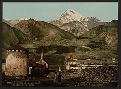 19th-century postcard of the Georgian Military Road near Mount Kazbegi
 -
 Mount Kazbek from the outside of the Gergeti Trinity Church
 -

-

-
 Crevasses of the Gergeti Glacier
 -
 Kazbegi Mountain, August 2019


_range,_Caucasus,_Georgia.jpg)


Notes[edit]
References[edit]
- ^ a b c "European Russia and the Caucasian States: Ultra-Prominence Page". peaklist.org. Retrieved 2014-05-25.
- ^ "Gora Kazbek, Georgia". Peakbagger.com. Retrieved 2015-05-25.
- ^ Страны Мира. ОЛМА Медиа Групп. 1974. p. 168. ISBN 978-5-94849-423-4.
- ^ a b Арджеванидзе 1954, p. 227.
- ^ a b Дахкильгов 1989, p. 99.
- ^ a b c "Kazbek". Global Volcanism Program. Smithsonian Institution. Retrieved 2021-06-24.
- ^ "მყინვარი", Donald Rayfield et al., A Comprehensive Georgian-English Dictionary (2006)
- ^ a b c d This article incorporates text from a publication now in the public domain: Chisholm, Hugh, ed. (1911). "Kasbek". Encyclopædia Britannica. Vol. 15 (11th ed.). Cambridge University Press. p. 685.
- ^ Georgia: A Sovereign Country of the Caucasus. Odyssey Publications: Hong Kong. 1999. ISBN 962-217-748-4.
- ^ "Moyennes 1981-2010 Géorgie" (in French). Retrieved 11 November 2019.
- ^ "Météo Climat stats for Kazbek". Météo Climat. Retrieved 11 November 2019.
Sources[edit]
- Арджеванидзе, И.А. (1954). Военно-грузинская дорога: Краеведческий очерк с приложением схематической карты маршрута и библиографии [Georgian Military Road: Local history essay with the appendix of a schematic map of the route and bibliography] (in Russian). Tbilisi: Госиздат Грузинской ССР. pp. 1–250.
- Дахкильгов, Ш.Э. (1989). Слово о родном крае (Записки краеведа) [A word about the native land (Notes of a local historian)] (in Russian). Grozny: Чеч.-Инг. кн. изд-во. pp. 1–149. ISBN 5-7666-0023-2.
External links[edit]
- "Mount Kazbek". Peakware.com. Archived from the original on 2016-03-04. – photos
- Normal climbing route to Mount Kazbek – detailed description
- Different ways to climb mt Kazbek – detailed description
| International | |
|---|---|
| National | |
| Geographic | |
- Stratovolcanoes of Russia
- Mountains of Mtskheta-Mtianeti
- Mountains of North Ossetia–Alania
- Volcanoes of Georgia (country)
- Potentially active volcanoes
- Georgia (country)–Russia border
- International mountains of Europe
- Geography of Mtskheta-Mtianeti
- Five-thousanders of the Caucasus
- Holocene stratovolcanoes
- Stratovolcanoes of Asia
- Stratovolcanoes of the Caucasus