
Jewish Quarter (Jerusalem)

.jpg)

The Jewish Quarter (Hebrew: הרובע היהודי, HaRova HaYehudi; Arabic: حارة اليهود, Harat al-Yehud) is one of the four traditional quarters of the Old City of Jerusalem. The area lies in the southwestern sector of the walled city, and stretches from the Zion Gate in the south, along the Armenian Quarter on the west, up to the Street of the Chain in the north and extends to the Western Wall and the Temple Mount in the east.[1] In the early 20th century the Jewish population of the quarter reached 19,000.[2]
During the 1948 war, the Jewish Quarter fought the Arab Legion as part of the battle for Jerusalem, and the Hurva synagogue was blown up by Arab legionnaires. On May 1948, the Jewish Quarter surrendered; some Jews were taken captive, and the rest were evacuated. A crowd then systemtically pillaged and razed the quarter.[3]
After Israel captured East Jerusalem during the 1967 Six-Day War, the quarter was earmarked for rehabilitation as a tourist destination and a residential neighborhood, and in the years that followed, a large-scale reconstruction and conservation project was undertaken.[4] This project included archeological excavations, which uncovered many remains from the First and Second Temple periods, including the Israelite Tower, the Broad Wall, the Burnt House and the Herodian Quarter, along with remains from later periods, such as the Byzantine Cardo and the Nea Church.[5][6][7]

As of 2013, the quarter is inhabited by around 3,000 residents and 1,500 students,[8] and is home to numerous yeshivas and synagogues, most notably the Hurva Synagogue, destroyed numerous times and rededicated in 2010. The quarter is also the site of two historical mosques – the Sidna Omar Mosque and the Al Dissi Mosque – both of which have been closed since the Six-Day War.[9]
Boundaries
In late medieval times, the Jewish part of the Old City was known as Haret el-Yahud (where Yahud is Arabic for Jews), in the south-west part of what is today known as the Jewish Quarter.[10] The convention of the modern boundaries of the Jewish Quarter may have originated in its current form in the 1841 British Royal Engineers map of Jerusalem,[11] or at least Reverend George Williams' subsequent labelling of it.[12] The city had previously been divided into many more harat (Arabic: حارَة, romanized: Hārat: "quarters", "neighborhoods", "districts" or "areas", see wikt:حارة).[13] From the mid-19th century onwards, the population of Jews in Jerusalem grew considerably, into the eastern part of the Armenian Quarter and the southern part of the Moslem Quarter; as Adar Arnon writes: "neither the traditional term 'Haret el-Yahud' nor its modern counterpart 'Jewish Quarter' could cope with the expansion of the area inhabited by Jews in the south of the Old City in the late nineteenth century".[14]
The table below shows the evolution of the Jewish Quarter and the overlapping Armenian Quarter, from 1495 up until the modern system:[15]
| Local divisions | Western divisions | |||||
|---|---|---|---|---|---|---|
| Date | 1495 | 1500s | 1800s | 1900 | 1840s onwards | |
| Source | Mujir al-Din | Ottoman Census | Traditional system | Ottoman Census | Modern maps | |
| Quarters | Bani Harith | Bani Harith | Jawa'na | Sharaf | Armenian Quarter | West |
| Dawiyya | North | |||||
| Arman ("Armenian") | Sihyun | Arman | South | |||
| Yahud ("Jewish") | Yahud | East | ||||
| Risha | Silsila | Jewish Quarter | South | |||
| Maslakh | ||||||
| Saltin | Khawaldi | |||||
| Sharaf | Sharaf (Alam) | |||||
| 'Alam | North | |||||
| Magharba ("Moroccan / Maghrebi") | Magharba | Magharba | East | |||
History
Second Temple period
Jerusalem stood on two heights during the late Second Temple period, the western hill being the one which was called the "Upper Market," or simply the "Upper City" by Josephus (Hebrew: שוק העליון).[16][17][18][19] The Phasael tower (now called the Tower of David) was also situated in the Upper City, a place used as a stronghold for Simon Bar Giora during the First Jewish–Roman War.[20]
Late Roman period

In CE 135, when the Roman Emperor Hadrian built the city of Aelia Capitolina on the ruins of ancient Jerusalem, the Tenth Legion set up their camp on the land that is now the Jewish Quarter.[21] New structures, such as a Roman bathhouse, were built over the Jewish ruins.[22]
Ottoman period
| Old Yishuv |
|---|
 |
| Key events |
| Key figures |
|
| Economy |
| Philanthropy |
| Communities |
| Synagogues |
| Related articles |
The Jewish quarter was initially located near the Gate of the Moors and Coponius Gate, in the southwestern part of the Western Wall.[23] Most of the housing property consisted of Muslim religious endowments, and was rented out to Jews.[24]
The population of the quarter was not homogeneously Jewish, such a rule being neither desired by the Jewish inhabitants nor enforced by the Ottoman rulers. During the Ottoman era, most of the homes in the quarter were leased from Muslim property owners. This is one of the reasons for the growth of buildings west of the city in the last years of the Ottoman Empire since land outside the city wall was freehold (mulk) and easier to acquire.[25]
While most residents of Jerusalem in the 19th century preferred to live near members of their own community, there were Muslims living in the Jewish Quarter and Jews living in the Muslim Quarter. Many Jews moved to the Muslim Quarter toward the end of the century due to intense overcrowding in the Jewish Quarter.[26]
In 1857, an organization of Dutch and German Jews named Kollel Hod (kolel standing for "society" or "community" and Hod being an abbreviation of Holland and Deutschland) bought a plot of land on which, between 1860 and 1890, the Batei Mahse ("Shelter for the Needy" in Hebrew) housing complex was built.[27][28] The most prominent building of the project, the two-storey Rothschild House, built in 1871 with money donated by Baron Wilhelm Carl von Rothschild, stands on the west side of the Batei Mahse Square.[29][30]
Rashid Khalidi calculated that the quarter "originally" covered "four or five acres" (c. 16,200-20,250 m2), of which prior to 1948 the Jewish-owned property amounted to less than 20%.[31]
British Mandate period

Between December 1917 and May 1948, the entire city of Jerusalem was part of British-administered Palestine, known after 1920 as Mandatory Palestine.
1947–48 hostilities


Background
Between 1910 and 1948, the number of Jews in Jerusalem rose from 45 to 100 thousand and within these totals the Old City's Jewish population fell from 16 to 2 thousand over the same period.[32] According to Benny Morris, quoting a British diplomat, the nearly all-Orthodox community were "on good terms with their Arab neighbours", resented the Haganah presence, and "were loath to see their homes sacrificed to Zionist heroics".[33] Before 1948, the quarter extended over 4 or 5 acres, and Jewish-owned property amounted to less than 20% of that.[31]
December 1947 events
Following a battle on the 11 December 1947, the day after Jewish forces in the quarter had been reinforced by Irgun and Haganah units, the British set troops to positions between the Arabs and Jews and after this, the Old City remained largely quiet until the British evacuation.[34][32]
After Irgun bomb attacks outside the Damascus Gate on 13 and 29 December 1947, resulting in the death of 18 Arabs and 86 injured including women and children, the Arabs set roadblocks outside the Old City cutting off the Jewish Quarter. The British approved this while ensuring supplies of food and the safety of the residents.[35][36][37]
May 1948 cease-fire agreement
On April 28, 1948 Francis Sayre, the President of the United Nations Trusteeship Council announced that both Moshe Shertok of the Jewish Agency and Jamal al-Husayni of the Higher Arab Committee had agreed to recommend to their respective communities in Palestine: (a) the immediate cessation of all military operations and acts of violence within the Old City; (b) the issue of cease-fire orders to this effect at the earliest possible moment; and (c) that the keeping of the truce should be observed by an impartial commission reporting to the Trusteeship Council. At the May 3 Trusteeship Council meeting, Sayre announced that a cease-fire order had been issued the previous day. On May 7, General Cunningham, the High Commissioner met Arab League representatives including Azzam Pasha, the Secretary-General of the League and obtained approval for a cease-fire agreement covering all of Jerusalem provided that the Jews also agreed, this being forthcoming later the same day when the Haganah issued a cease-fire order to its troops in the Jerusalem area.[38]
British withdrawal
According to a diary covering the period 12 May to July 16, 1948, of Hugh Jones, a British clergyman with Christ Church, British troops were withdrawn from their positions protecting the Jewish Quarter in the evening of May 13, 1948. Haganah forces occupied the positions vacated by the British army and the High Commissioner left Jerusalem early the next morning.[39][40] Morris says that there were 90 mostly Haganah defenders, joined by 100 more after the British left their positions.[33]
Fighting
In a letter sent to the United Nations in 1968, in response to Jordanian allegations, Israel noted that Colonel Abdullah el Tell, local commander of the Jordanian Arab Legion, described the destruction of the Jewish Quarter in his memoirs (Cairo, 1959):
"The operations of calculated destruction were set in motion. ... I knew that the Jewish Quarter was densely populated with Jews who caused their fighters a good deal of interference and difficulty. ... I embarked, therefore, on the shelling of the Quarter with mortars, creating harassment and destruction. ... Only four days after our entry into Jerusalem the Jewish Quarter had become their graveyard. Death and destruction reigned over it.... As the dawn of Friday, May 28, 1948, was about to break, the Jewish Quarter emerged convulsed in a black cloud—a cloud of death and agony."
— Abdullah el-Tal according to Yosef Tekoah (Permanent Representative of Israel to the United Nations).[41]
Abdullah al-Tal justified the destruction of the Jewish quarter by claiming that had he not destroyed the homes, he would have lost half his men. He adds that "the systematic demolition inflicted merciless terror in the hearts of the Jews, killing both fighters and civilians."[42]
Jewish surrender
The defenders surrendered on May 28, 1948, and Mordechai Weingarten negotiated the surrender terms.[citation needed]
Expulsion of the inhabitants
The Jordanian commander is reported to have told his superiors: "For the first time in 1,000 years not a single Jew remains in the Jewish Quarter. Not a single building remains intact. This makes the Jews' return here impossible."[43]
Hurva and Tifereth Israel Synagogues
In respect of the destruction of the Hurva Synagogue, originally built in 1701, according to author Simone Ricca, Israeli, Jordanian and Palestinian sources generally present divergent versions of the events that led to the destruction of the building. Whereas Israeli sources say that the Jordanian army purposefully demolished the synagogue after the cessation of the fighting, Jordanian and Palestinian sources present the destruction of the synagogue as a direct result of the fighting that took place in the Old City.[44]

Vatikiotis writes of the diary kept by Constantine X. Mavridis of the Greek Consulate General, Jerusalem,[45] "an eyewitness account of the contest between Arabs and Jews for the control of the Old City which went on for at least six months during the Palestine War (1948)".[46] According to the diary:
The Arab guerrilla fighters who later joined with the Legion of Transjordan were preoccupied with clearing the Jews from the Jewish Quarter inside the Old City, who even used their own synagogues as strongholds from where attacks were made. Qawuqji and the Transjordanian army were continuously pounding the Jewish Quarter. The Tiferet Yisrael Synagogue was first destroyed, and was followed by the most famous and historic Hurva Synagogue, which was destroyed on May 27. But the Arab Headquarters had warned the Jewish Headquarters through the International Red Cross that unless the armed Jewish forces withdrew from the Synagogue within a certain time limit, they would be compelled to attack it. Since there was no reply from the Jewish side, as it was stated officially by the Red Cross, the Arabs bombed and destroyed it.
Jordanian period
Damage and destruction
According to Chief Rabbi Rabbi Isaac Herzog, speaking in Tel Aviv less than two weeks after the surrender and reported on 9 June 1948, of 27 synagogues in the Old City, 22 had been "razed by fire and explosives", with over 500 scrolls and scores of old Jewish manuscripts and sacred vessels being destroyed since the surrender date.[47] During the following nineteen years of Jordanian rule, a third of the Jewish Quarter's buildings were demolished.[48] This one-third destruction is doubted by British archaeologist Kay Prag, based on an aerial photograph published by Yigal Yadin in 1976.[49] She comments that the quarter, damaged and evacuated in 1948, had been rather neglected than systematically destroyed, especially since it had been used as a home by Arab refugees.[49] As part of a letter sent by Israel to the United Nations in 1968 in response to Jordanian complaints, it was stated all but one of the thirty-five "Jewish houses of worship" in the Old City were destroyed and that "the synagogues" were "razed or pillaged and stripped and their interiors used as hen-houses or stables."[41] According to Dore Gold addressing the United Nations Security Council in 1998, "Fifty-eight synagogues, including the 700-year-old Hurva synagogue, were destroyed and desecrated."[50]
Palestinian refugees
In the wake of the 1948 war, the Red Cross housed Palestinian refugees in the depopulated and partly destroyed Jewish Quarter.[51] This grew into the Muaska refugee camp managed by UNRWA, which housed refugees from 48 locations now in Israel.[52] Over time many poor non-refugees also settled in the camp.[52] Conditions became unsafe for habitation due to lack of maintenance and sanitation.[52] Jordan had planned transforming the quarter into a park,[53] but neither UNRWA nor the Jordanian government wanted the negative international response that would result if they demolished the old Jewish houses.[52] In 1964 a decision was made to move the refugees to a new camp constructed near Shuafat.[52] Most of the refugees refused to move, since it would mean losing their livelihood, the market and the tourists, as well as reducing their access to the holy sites.[52] In the end, many of the refugees were moved to Shuafat by force during 1965 and 1966.[51][52] The Al-Bashura Market, today's Cardo souvenir market, specialised in selling second-hand clothing.[54]
State of Israel

The Jewish Quarter remained under Jordanian rule until the Six-Day War in June 1967 when Israel occupied it. During the first week after taking the Old City, Israel dynamited the Mughrabi Quarter, demolishing 135 houses, and two mosques on waqf property and evicting the 650 Arab residents in order that, on the razed ground, a plaza could be created at the foot of the Western Wall.[55][56]
On 18 April 1968, the Israeli minister of finance, Pinchas Sapir, issued an order for the expropriation of 29 acres (116 dunums) extending from the Western Wall to the Armenian Quarter, and from Tariq Bab al-Silsilah in the north, to the city's southern walls. 700 stone buildings were subject to the expropriation. Of these 105 had been Jewish properties before 1948. The remainder was Palestinian property, comprising 1,048 apartments and 437 workshops and business stores. The aim, stated to be assuming land for "public purposes", was to establish residences for an Israeli Jewish community.[55] In 1969, the Jewish Quarter Development Company was established under the auspices of the Construction and Housing Ministry to rebuild the desolate Jewish Quarter.[57]
According to an article by Thomas Abowd in the Jerusalem Quarterly (Hawliyat al-Quds), the Arab population of the quarter reached approximately 1,000, most of whom were refugees[58] who had appropriated the evacuated Jewish houses in 1949. Although many had originally fled the Quarter in 1967, they later returned after Levi Eshkol ordered that the Arab residents not be forcefully evacuated from the area. With Menachem Begin's rise to power in 1977, he decided that 25 Arab families be allowed to remain in the Jewish Quarter as a gesture of good will, while the rest of the families who had not fled during the Six-Day War were offered compensation in return for their evacuation, although most declined.[2] The quarter was rebuilt in keeping with the traditional standards of the dense urban fabric of the Old City. Residents of the quarter hold long-term leases from the Israel Lands Administration.[57] As of 2004 the quarter's population stood at 2,348[59] and many large educational institutions have taken up residence.
Beginning in the years immediately after 1967, around 6,000 Arabs were evicted from the Jewish Quarter, and the start of exclusion of Palestinians from appropriated land by the private company in charge of its development, for the reason that they were not Jewish. This later became legal precedent in 1978 when the Supreme Court made a decision in the case of Mohammed Burqan, in which the Court ruled that, while Burqan did own his home, he could not return because the area had "special historical significance" to the Jewish people.[60]
Archaeology
Settlement periods; excavations
The area in which the modern Jewish Quarter now stands is the western hill of the historical Old City, which has been part of the pre-medieval walled city twice: during the First Temple period between the reign of King Hezekiah around 700 BCE and the destruction by Nabuchadnezzar in 586 BCE, and again from the Hasmonean period to the Roman destruction of 70 CE.[61] This was documented after 1967, when before being rebuilt, the quarter was partially excavated[62] under the supervision of Hebrew University archaeologist Nahman Avigad.[63] Some archaeological remains were left in situ and made accessible, either in outdoor parks, or in a series of museums set up between one and three storeys beneath the level of the current city.[citation needed]
First Temple period
Among the First Temple period finds were portions of the 8th and 7th century BCE city walls, in the area of the Israelite Tower, probably including parts of a gate where numerous projectiles were found, attesting to the Babylonian sack of Jerusalem in 586 BCE.[63][64][65] Another part of the late 8th-century BCE fortification discovered was dubbed the "broad wall", after the way it was described in the Book of Nehemiah, built to defend Jerusalem against the Assyrian siege of Jerusalem of 701 BCE.[64][63][66]
Second Temple period
From the Second Temple period Avigad unearthed a palatial mansion from the Herodian period,[67] possibly the residence of Annas the High Priest.[68] In its vicinity archaeologists found a depiction of the Temple menorah, carved while its model still stood in the Temple, engraved in a plastered wall.[68] The palace has been destroyed during the final days of the Roman siege of 70 CE, suffering the same fate as the so-called Burnt House, a building belonging to the Kathros priestly family.[64][69]
Roman period
In 2010, Israeli archaeologists uncovered a pool built by the Roman Tenth Legion "Fretensis". The dig uncovered steps leading to the pool, a white mosaic floor and hundreds of terracotta roof tiles stamped with the name of the Roman unit, indicating that the pool had been roofed over. It may have been part of a larger complex where thousands of soldiers once bathed and suggests that the Roman city was larger than previously thought.[70]
Byzantine period
Avigad's dig also unearthed the remains of the Byzantine Nea Church,[71] standing along the Byzantine southern section of the cardo maximus, a 22.5-metre (74 ft)-wide road (a 12.5 m wide street bordered by pavements each 5 m wide) flanked by shops[72] which also passed by the Constantinian Church of the Resurrection further to the north.
Early Muslim (Abbasid) period
An Arabic inscription, unearthed in the Jewish Quarter in 2010, dates back to 910 CE and commemorates the granting of an estate in Jerusalem by the Abbasid Caliph.[73]
Landmarks

Archaeological sites
- Broad Wall – 8th-century BCE city wall segment
- Burnt House – mansion of the Kathros/Qatros priestly family, burnt down in 70 CE
- Cardo – ancient Byzantine street
- Herodian Quarter – Wohl Archaeological Museum with the palatial Herodian mansion, burnt down in 70 CE
- Israelite Tower – Iron Age fortifications, later incorporated into the Hasmonean city walls
- Nea Church – remains of huge 6th-century Byzantine church
- Church of Saint Mary of the Germans – remains of a 12th-century Crusader church
Apartment buildings
- Batei Mahse
- "The Chush" or "the Hush", compound of residential courtyards dating from the early 1800s, restored in 1977 by the Israeli architect Moshe Safdie
Markets
- Cardo market
- Hurva Square
Mosques
- Sidna Omar Mosque (not in use)
- Al Dissi Mosque (not in use) [74]
Museums
Synagogues
Yeshivas
- Aish HaTorah
- Beit El Kabbalist yeshiva
- Bircas HaTorah
- Porat Yosef Yeshiva
- Yeshivat HaKotel (Western Wall Yeshiva)
- Yeshivat Netiv Aryeh
Other
- The Temple Institute, aiming at building a third Jewish temple on the Temple Mount. Runs a Temple museum in the Jewish Quarter.
- Metivta Sephardic Center
Gallery
-
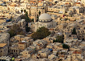 Hurva Synagogue and Sidna Omar mosque in the Jewish Quarter
 -
 Rothschild House (1871), part of Batei Mahse complex (1860–90)
 -
 The Temple Institute's vision of the Temple menorah
 -
 Cardo Maximus
 -
 Covered section of the Crusader Cardo
 -
 "The oil press art gallery" with mosaics by Yael Portugheis
 -
![The Spanish-style patio (courtyard)[1] of the Sephardic House (the hotel run by the Sephardic Educational Center)](//upload.wikimedia.org/wikipedia/commons/thumb/d/d9/Renovated_Patio.jpg/351px-Renovated_Patio.jpg) The Spanish-style patio (courtyard)[1] of the Sephardic House (the hotel run by the Sephardic Educational Center)
The Spanish-style patio (courtyard)[1] of the Sephardic House (the hotel run by the Sephardic Educational Center)


.jpg)

.jpg)
![The Spanish-style patio (courtyard)[1] of the Sephardic House (the hotel run by the Sephardic Educational Center)](https://wiki.alquds.edu/?query=File:Renovated_Patio.jpg)
References
- ^ Kollek, Teddy (1977). "Afterword". In John Phillips (ed.). A Will to Survive – Israel: the Faces of the Terror 1948-the Faces of Hope Today. Dial Press/James Wade.
28+3⁄4 acres
- ^ a b Hattis Rolef, Susan (2000). "The Jewish Quarter in Jerusalem". Architecture of Israel Quarterly. Retrieved 2007-12-26.
- ^ Morris, Benny (2008). 1948: A History of the First Arab-Israeli War. New Haven [Conn.]: Yale University Press. pp. 218–219. ISBN 978-0-300-14524-3. OCLC 402826490.
On 26–27 May, the Legionnaires took the Hurvat Israel (or "Hurva") Synagogue, the quarter's largest and most sacred building, and then, without reason, blew it up. "This affair will rankle for generations in the heart of world Jewry," predicted one Foreign Office official. [...] The Legionnaires took prisoner 290 healthy males, aged fifteen to fifty—two-thirds of them, in fact, noncombatants—and fifty-one of the wounded. The other wounded and twelve hundred inhabitants were accompanied by the Legionnaires to Zion Gate and freed. The quarter was then systematically pillaged and razed by the mob. The fall of the Jewish Quarter, an important national site, dealt a severe blow to Yishuv morale
- ^ Slae, Bracha; Kark, Ruth; Shoval, Noam (2012). "Post-war reconstruction and conservation of the historic Jewish Quarter in Jerusalem, 1967–1975". Planning Perspectives. 27 (3): 369–392. doi:10.1080/02665433.2012.681138. ISSN 0266-5433. S2CID 143835754.
- ^ Geva, H. (2006). The Settlement on the Southwestern Hill of Jerusalem at the End of the Iron Age: A Reconstruction Based on the Archaeological Evidence. Zeitschrift des Deutschen Palästina-Vereins (1953-), (H. 2), 140-150.
- ^ Avigad, N. (1970). Excavations in the Jewish Quarter of the Old City of Jerusalem, 1970 (Second Preliminary Report). Israel Exploration Journal, 129-140.
- ^ Raphael, K. (2015). Jerusalem, The Jewish Quarter. Hadashot Arkheologiyot: Excavations and Surveys in Israel/חדשות ארכיאולוגיות: חפירות וסקרים בישראל.
- ^ "Demography in Jerusalem's Old City". The Jerusalem Post | JPost.com. Retrieved 2023-07-10.
- ^ TPS, Baruch Yedid /. "Jordan Reopening Mosque Adjacent to Hurva Synagogue in Heart of Jerusalem's Jewish Quarter". Retrieved 2022-12-20.
- ^ Arnon, Adar (1992). "The Quarters of Jerusalem in the Ottoman Period". Middle Eastern Studies. 28 (1). Taylor & Francis, Ltd.: 12. ISSN 0026-3206. JSTOR 4283477. Retrieved 2023-05-31.
The continuous Moslem area of the city occupied its entire east half penetrating its west half at the north, near Damascus Gate. Excluding its south part and the north-west bulge, this region will be defined in the nineteenth century as the 'Moslem Quarter'. In the west part of the city lay Haret en-Nasara in the middle of the area which will be named in modern times the 'Christian Quarter'. Two minorities dwelt in the south outskirts of the city: Jews in Haret el-Yahud, in the south-west part of the future Jewish Quarter and Armenians around their monastery in the south part of the modern Armenian Quarter. The layout of ethno-religious groups in sixteenth-century Jerusalem agreed then with the guidelines of their dispersal in the city in the thirteenth century described above.
- ^ Teller, Matthew (2022). Nine Quarters of Jerusalem: A New Biography of the Old City. Profile Books. p. Chapter 1. ISBN 978-1-78283-904-0. Retrieved 2023-05-30.
What wasn't corrected, though - and what, in retrospect, should have raised much more controversy than it did (it seems to have passed completely unremarked for the last 170-odd years) - was [Aldrich and Symonds's] map's labelling. Because here, newly arcing across the familiar quadrilateral of Jerusalem, are four double labels in bold capitals. At top left Haret En-Nassara and, beneath it, Christian Quarter; at bottom left Haret El-Arman and Armenian Quarter; at bottom centre Haret El-Yehud and Jews' Quarter; and at top right - the big innovation, covering perhaps half the city - Haret El-Muslimin and Mohammedan Quarter. No map had shown this before. Every map has shown it since. The idea, in 1841, of a Mohammedan (that is, Muslim) quarter of Jerusalem is bizarre. It's like a Catholic quarter of Rome. A Hindu quarter of Delhi. Nobody living there would conceive of the city in such a way. At that time, and for centuries before and decades after, Jerusalem was, if the term means anything at all, a Muslim city. Many people identified in other ways, but large numbers of Jerusalemites were Muslim and they lived all over the city. A Muslim quarter could only have been dreamt up by outsiders, searching for a handle on a place they barely understood, intent on asserting their own legitimacy among a hostile population, seeing what they wanted to see. Its only purpose could be to draw attention to what it excludes.
- ^ Teller, Matthew (2022). Nine Quarters of Jerusalem: A New Biography of the Old City. Profile Books. p. Chapter 1. ISBN 978-1-78283-904-0. Retrieved 2023-05-30.
But it may not have been Aldrich and Symonds. Below the frame of their map, printed in italic script, a single line notes that 'The Writing' had been added by 'the Revd. G. Williams' and 'the Revd. Robert Willis'… Some sources suggest [Williams] arrived before [Michael] Alexander, in 1841. If so, did he meet Aldrich and Symonds? We don't know. But Williams became their champion, defending them when the Haram inaccuracy came up and then publishing their work. The survey the two Royal Engineers did was not intended for commercial release (Aldrich had originally been sent to Syria under 'secret service'), and it was several years before their military plan of Jerusalem came to public attention, published first in 1845 by their senior officer Alderson in plain form, without most of the detail and labelling, and then in full in 1849, in the second edition of Williams's book The Holy City. Did Aldrich and/or Symonds invent the idea of four quarters in Jerusalem? It's possible, but they were military surveyors, not scholars. It seems more likely they spent their very short stay producing a usable street-plan for their superior officers, without necessarily getting wrapped up in details of names and places. The 1845 publication, shorn of street names, quarter labels and other detail, suggests that… Compounding his anachronisms, and perhaps with an urge to reproduce Roman urban design in this new context, Williams writes how two main streets, north-south and east-west, 'divide Jerusalem into four quarters.' Then the crucial line: 'The subdivisions of the streets and quarters are numerous, but unimportant.' Historians will, I hope, be able to delve more deeply into Williams's work, but for me, this is evidence enough. For almost two hundred years, virtually the entire world has accepted the ill-informed, dismissive judgementalism of a jejune Old Etonian missionary as representing enduring fact about the social make-up of Jerusalem. It's shameful… With Britain's increased standing in Palestine after 1840, and the growth of interest in biblical archaeology that was to become an obsession a few decades later, it was vital for the Protestant missionaries to establish boundaries in Jerusalem… Williams spread his ideas around. Ernst Gustav Schultz, who came to Jerusalem in 1842 as Prussian vice-consul, writes in his 1845 book Jerusalem: Eine Vorlesung ('A Lecture'): 'It is with sincere gratitude I must mention that, on my arrival in Jerusalem, Mr Williams ... willingly alerted me to the important information that he [and] another young Anglican clergyman, Mr Rolands, had discovered about the topography of [Jerusalem].' Later come the lines: 'Let us now divide the city into quarters,' and, after mentioning Jews and Christians, 'All the rest of the city is the Mohammedan Quarter.' Included was a map, drawn by Heinrich Kiepert, that labelled the four quarters, mirroring Williams's treatment in The Holy City.
- ^ Arnon, Adar (1992). "The Quarters of Jerusalem in the Ottoman Period". Middle Eastern Studies. 28 (1). Taylor & Francis, Ltd.: 5–7. ISSN 0026-3206. JSTOR 4283477. Retrieved 2023-05-31.
The origin of this ethno-religious partition lies in the nineteenth-century modern survey maps of Jerusalem drawn by Europeans - travellers, army officers, architects - who explored the city. The following verbal geographical definitions of the quarters will refer to this contemporarily prevailing division of the Old City. The ethno-religious partition of the Old City on the nineteenth-century maps reflected a situation rooted in history. Crusader Jerusalem of the twelfth and thirteenth centuries, the capital of the Latin Kingdom of Jerusalem, was partitioned among the residential territories of people from different European countries, Oriental Christian communities and knights orders. In 1244 Jerusalem returned to Moslem hands when it became part of the Ayyubid Sultanate of Egypt. The change of government coincided with a devastation of the city by the Central Asian tribe of Khawarizm which all but annihilated the city's population. In 1250 the Mamluks rose to power in Egypt. Under their rule Jerusalem became a magnet to pilgrims from all parts of the Islamic world. People from various regions, towns and tribes settled in it. The parts of the city preferred by the Moslems were those adjoining the north and west sides of the Temple Mount (the other two sides lay outside the city) on which stood their two revered mosques, the Dome of the Rock and al-Agsa Mosque. Christians from different denominations resettled in the north-west of the city, at the vicinity of the Church of the Holy Sepulchre. Armenians settled in its south-west, near their Cathedral of St James which had been destroyd by the Khawarizms. Jews settled in Jerusalem, beginning with the second half of the thirteenth century, near the south wall of the city, because the territory there was not settled by any other community and separated from their venerated place, the West (Wailing) Wall, only by a small quarter of North-African Moslems. When the city changed hands again at the beginning of the sixteenth century, falling to the Ottoman Turks, no change in the city's population, and hence in its quarters occurred.
- ^ Arnon, Adar (1992). "The Quarters of Jerusalem in the Ottoman Period". Middle Eastern Studies. 28 (1). Taylor & Francis, Ltd.: 16. ISSN 0026-3206. JSTOR 4283477. Retrieved 2023-05-31.
The continuous flow of Jews to Jerusalem since the 1840s (see below) caused Haret el-Yahud to extend to all the previously sparsely populated area south of Bab es-Silsila Street (except Haret el-Magharba) and the east part of the Armenian Quarter. Jews settled also north of Bab es-Silsila Street at the south part of the Moslem Quarter (see below). In fact, neither the traditional term 'Haret el-Yahud' nor its modern counterpart 'Jewish Quarter' could cope with the expansion of the area inhabited by Jews in the south of the Old City in the late nineteenth century. Northwards lay the two medieval quarters of Qattanin and 'Agabet et-Takiya which being called after subsidiary streets have been pushed along the years into the internal parts of the area west of the Temple Mount by two quarters named after main streets in that region and in the whole city, Wad and Bab es-Silsila.
- ^ Arnon, Adar (1992). "The Quarters of Jerusalem in the Ottoman Period". Middle Eastern Studies. 28 (1). Taylor & Francis, Ltd.: 25–26. ISSN 0026-3206. JSTOR 4283477. Retrieved 2023-05-31.
- ^ Josephus, Jewish War, Book V, 4:1, William Whiston edition (London, 1737) via penelope.uchicago.edu, accessed 9 September 2020.
- ^ For the use of this term in the Mishnah, see Mishnah Shekalim 8:1 (Herbert Danby's edition, p. 161 (note 3).
- ^ "Jerusalem: The Old City". Jewish Virtual Library. Retrieved 16 September 2020., s.v. The Jewish Quarter
- ^ "Jerusalem-The Upper City during the Second Temple Period". Israel Ministry of Foreign Affairs. Retrieved 16 September 2020.
- ^ Josephus, The Jewish War 5.4.3 (5.156); 7.2.1, the latter of which denotes the following: "This Simon, during the siege of Jerusalem, was in the Upper City, but when the Roman army were gotten within the walls, and were laying the city waste, he then took the most faithful of his friends with him...and then let himself and them all down into a certain subterraneous cavern that was not visible above ground."
- ^ The Christian Heritage in the Holy Land edited by Anthony O'Mahony with Goran Gunner and Hintlian. ISBN 1-900269-06-6. Pages 15 and 18. Jerome Murphy-O'Connor, "Pre-Constantinian Christian Jerusalem". At this time Hadrian expelled all Jews from the territory.
- ^ "The Mughrabi Gate Access - the Real Story", Israel Antiquities Authority
- ^ Har-El, Menashe (1977). This is Jerusalem. Canaan Publishing House. p. 276.
- ^ Bowman, Glenn (2014). "Sharing and Exclusion: The Case of Rachel's Tomb" (PDF). Jerusalem Quarterly. 58: 30–49 [p. 40].
- ^ Scholch, Alexander (1989). "Jerusalem in 19th Century (1831 – 1917 AD)". In Asali, K. J. (ed.). Jerusalem in History. p. 234. ISBN 0-905906-70-5. Quoting Muhammad Adib al-Amiri, "Al Quds al-'Arabiyya", Amman, 1971, page 12 (85% of Jewish Quarter was waqf owned), and 'Arif al-'Arif, "Al-Nakba", vol 2, Sidon and Beirut, page 490 (90%).
- ^ Ben-Arieh, Yehoshua (1984). Jerusalem in the Nineteenth Century: The Old City. Yad Yitzhak Ben Zvi and St. Martin's Press. p. 14. ISBN 0-312-44187-8.
- ^ "Batei Mahse". The Company for the Reconstruction and Development of the Jewish Quarter in the Old City of Jerusalem Ltd. Archived from the original on 20 August 2016. Retrieved 8 July 2016.
- ^ David Eisenstadt. "The Dawn of Modernity – The Beginnings of the New City". Jerusalem: Life Throughout the Ages in a Holy City. Ingeborg Rennert Center for Jerusalem Studies, Bar-Ilan University. Archived from the original on 2015-09-26. Retrieved 2013-05-19.
- ^ "Municipality website: Batei Mahseh Square, retrieved 7 July 2016". Archived from the original on 2016-06-03. Retrieved 2016-07-06.
- ^ "Batei Mahseh Square"
- ^ a b Khalidi, Rashid (1992). "The Future of Arab Jerusalem". British Journal of Middle Eastern Studies. 19 (2): 133–143 [pp. 137–8]. doi:10.1080/13530199208705557. JSTOR 195696.
Until 1967, moreover, the eastern section of the city had always been overwhelmingly Arab in both population and land ownership. This was true even in the Jewish quarter, where before 1948 Jewish-owned property constituted less than 20% of the quarter's original four or five acres.
(subscription required) - ^ a b "Part 2,Jerusalem:the Battle for the Old City". Retrieved 26 August 2019.
- ^ a b Morris, Benny (2008). 1948. Yale University Press. p. 217. ISBN 978-0-300-12696-9.
- ^ Itamar Radai (2016). Palestinians in Jerusalem and Jaffa, 1948: A Tale of Two Cities. Routledge. p. 39. ISBN 978-1-138-94653-8.
- ^ Uri Milstein (1996). History of the War of Independence: The first month. University Press of America. p. 53. ISBN 978-0-7618-0721-6.
- ^ John Quigley (February 2016). The International Diplomacy of Israel's Founders. Cambridge University Press. pp. 82–. ISBN 978-1-107-13873-5.
- ^ "Summary Record of Sixteenth Meeting of the United Nations Palestine Commission". United Nations. 21 January 1948. Retrieved 27 August 2019.
- ^ "May 15–22, 1948" (PDF). Keesing's Contemporary Archives.
- ^ Diary
- ^ Friedman, Matti (23 April 2012). "War diary: An eyewitness account of the 1948 battle for Jerusalem". The Times of Israel. Retrieved 27 August 2019.
- ^ a b Letter Dated 5 March 1968 from the Permanent Representative of Israel to the United Nations Addressed to the Secretary-General Archived 15 May 2011 at the Wayback Machine.
- ^ Avraham Zilka (1992). "1. Background: History of the Israeli-Palestinian Conflict". In Elizabeth Warnock Fernea and Mary Evelyn Hocking (ed.). The Struggle for Peace: Israelis and Palestinians. University of Texas Press. p. 53. ISBN 978-0-292-76541-2. Retrieved 23 May 2013.
- ^ Shragai, Nadav (November 28, 2006). "Byzantine arch found at site of renovated Jerusalem synagogue". Haaretz. Retrieved 2016-07-05.
- ^ Simone Ricca (2007). Reinventing Jerusalem: Israel's Reconstruction of the Jewish Quarter After 1967. I.B.Tauris. p. 105. ISBN 978-1-84511-387-2.
- ^ Mavrides, Constantine (1999). "Diaries (May 15 – December 30, 1948)" (PDF). In Tamari, Salim (ed.). Jerusalem 1948: The Arab Neighborhoods and their Fate in the War. pp. 277–293. ISBN 0-88728-274-1.
- ^ Vatikiotis, P. J. (1995). "The Siege of the Walled City of Jerusalem, 14 May–15 December 1948". Middle Eastern Studies. 31 (1): 139–145. doi:10.1080/00263209508701045. JSTOR 4283703.
- ^ "22 Synagogues Razed Heavy Damage in Old Jerusalem". National Library of Australia, Digitized Newspapers. 9 June 1948. Retrieved 29 August 2019.
- ^ Fisk, Robert (September 30, 2000). "Bloodbath at the Dome of the Rock". The Independent. Archived from the original on 2008-05-06. Retrieved 2007-12-26.
- ^ a b Prag, Kay (November 1982). "[Book review of] Yigael Yadin (ed.): Jerusalem revealed. Archaeology in the Holy City 1968–1974. London & New Haven: Yale University Press and Israel Exploration Society, 1976". Antiquity. 56 (218). Cambridge: Cambridge University Press: 234–236 [234]. doi:10.1017/S0003598X00054843. S2CID 163202099. Retrieved 9 September 2020.
- ^ "Jerusalem boundaries/Settlements – SecCo debate – Verbatim record". United Nations. 30 June 1998. Retrieved 29 August 2019.
- ^ a b Meron Benvenisti (1976). Jerusalem: The Torn City. Isratypeset. p. 70.
- ^ a b c d e f g Avi Plascov (1981). The Palestinian Refugees in Jordan 1948–1957. Frank Cass.
- ^ Shepherd, Naomi (1988). "The View from the Citadel". Teddy Kollek, Mayor of Jerusalem. New York City: Harper & Row Publishers. p. 20. ISBN 0-06-039084-0.
- ^ "Jerusalem Markets". The Arab Chamber of Commerce in Jerusalem. Retrieved 4 May 2021.
- ^ a b Michael Dumper, 'Israeli Settlement in the Old City of Jerusalem,' Journal of Palestine Studies, Summer 1992, Vol. 21, No. 4 (Summer, 1992), pp.32-53 pp.37-38
- ^ Esther Rosalind Cohen (1985). Human Rights in the Israeli-Occupied Territories, 1967–1982. Manchester University Press. p. 210. ISBN 978-0-7190-1726-1. Retrieved 23 May 2013.
On 11 June, twenty-five dwellings opposite the Wailing Wall (the Mugrabi Quarter) were demolished in order to provide access to the Jews' most holy place of worship.
- ^ a b Zohar, Gil (November 1, 2007). "Trouble in the Jewish Quarter". Jerusalem Post. Retrieved 2008-02-26.
- ^ The Moroccan Quarter: A History of the Present, Thomas Abowd, Jerusalem Quarterly, nº7, 2000. Retrieved 2012-07-22.
- ^ "shnaton C1404.xls" (PDF). Archived from the original (PDF) on 2009-09-24. Retrieved 2007-02-24.
- ^ Abowd, Thomas (2000). "The Moroccan Quarter: A History of the Present". Jerusalem Quarterly. 7. Retrieved 19 May 2013.
- ^ Murphy-O'Connor (2008), pp. 10–11 for the evolution of the city's outline, vide Fig. 1/3 for First Temple period, and 5-7 for Second Temple period; 75-76 for the Jewish Quarter.
- ^ Murphy-O'Connor (2008), pp. 75–76
- ^ a b c Geva, Hillel (2003). "Western Jerusalem at the end of the First Temple Period in Light of the Excavations in the Jewish Quarter". In Vaughn, Andrew G; Killebrew, Ann E (eds.). Jerusalem in Bible and archaeology: the First Temple period. Society of Biblical Literature. pp. 183–208. ISBN 978-1-58983-066-0.
- ^ a b c Geva, Hillel (2010). Jewish Quarter Excavations in the Old City of Jerusalem. Volume IV: The Burnt House of Area B and Other Studies (Abstract). Israel Exploration Society. Retrieved 9 September 2020 – via Harvard University website, the Shelby White and Leon Levy Program for Archaeological Publications.
- ^ Murphy-O'Connor (2008), pp. 76–78
- ^ Murphy-O'Connor (2008), p. 76, Fig. 1/3 (p.10)
- ^ Murphy-O'Connor (2008), pp. 80–82
- ^ a b Palatial Mansion, Carta Publishing House, Jerusalem. Accessed 9 September 2020.
- ^ Murphy-O'Connor (2008), p. 80
- ^ CBS News: Archaeologists Uncover Roman Pool in Jerusalem
- ^ Murphy-O'Connor (2008), pp.19, 83-84
- ^ Murphy-O'Connor (2008), pp. 78–79
- ^ jpost.com staff (17 February 2010). "Jewish Quarter: Arabic inscription found". The Jerusalem Post.
- ^ פרידסון, יעל (2019-11-21). ""עוד יהיה כאן פיצוץ": בקרוב מסגד בלב הרובע היהודי". Ynet (in Hebrew). Retrieved 2022-12-20.
Bibliography
- Bell, J. Bowyer (29 September 2017). Besieged: Seven Cities Under Siege. Taylor & Francis. ISBN 978-1-351-31410-7.
- Collins, Larry; Lapierre, Dominique (15 May 1988). O Jerusalem. Simon and Schuster. ISBN 978-0-671-66241-7.
- Gurney, Henry (2009). Golani, Motti (ed.). The End of the British Mandate for Palestine, 1948: The Diary of Sir Henry Gurney. Palgrave Macmillan. ISBN 9780230244733.
- Murphy-O'Connor, Jerome (2008). The Holy Land: An Oxford Archaeological Guide from Earliest Times to 1700. Oxford Archaeological Guides. Oxford: Oxford University Press. ISBN 978-0-19-923666-4. Retrieved 9 September 2020.
External links
31°46′34″N 35°13′56″E / 31.77611°N 35.23222°E

| Authority control databases: National |
|---|