
File:Wien - Hofburg, Leopoldinischer Trakt.JPG

Size of this preview: 800 × 513 pixels. Other resolutions: 320 × 205 pixels | 640 × 410 pixels | 1,024 × 656 pixels | 1,280 × 820 pixels | 2,560 × 1,640 pixels | 4,128 × 2,645 pixels.
Original file (4,128 × 2,645 pixels, file size: 9.62 MB, MIME type: image/jpeg)
| This is a file from the Wikimedia Commons. Information from its description page there is shown below. Commons is a freely licensed media file repository. You can help. |
Summary
| Description |
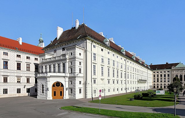
Deutsch: Westansicht des Leopoldinischen Traktes der Hofburg in der österreichischen Bundeshauptstadt Wien.
Das Verbindungsgebäude zwischen der Amalienburg und dem Schweizertrakt wurde unter Kaiser Leopold I. in den 1660er Jahren erbaut. Der Architekt war Filiberto Lucchese, die Ausführung oblag den italienischen Baumeistern Carl Martin und Dominico Carlone. 1668 brannte der Palast ab und wurde umgehendst wieder aufgebaut. Nach der Zweiten Wiener Türkenbelagerung 1683 wurde der Trakt von Giovanni Pietro Tencala neu aufgebaut und um eine Etage aufgestockt. 1752 erfolgte der Zubau eines Balkons durch die Hofsteinmetzmeister Elias Hügel und Johann Baptist Regondi. Da die alte Präsidentschaftskanzlei im Kanzleramt durch einen Bombentreffer unbenützbar geworden war, übersiedelte Ende 1946 die Präsidentschaftskanzlei in den Leopoldinischen Trakt. |
| Date | |
| Source | Own work |
| Author | C.Stadler/Bwag |
| Permission (Reusing this file) |
Deutsch: Hallo, du darfst mein Foto kostenlos nutzen, aber nenne mich bitte als Fotograf, beispielsweise „Foto: C.Stadler/Bwag“ oder © C.Stadler/Bwag; CC-BY-SA-4.0. Auf mehr Angaben bestehe ich nicht - im Gegensatz zu manch anderen, die die Vorgaben der unten angeführten Lizenzierung auf Punkt und Beistrich einfordern. English: Feel free to use my photos, but please mention me as the author like © C.Stadler/Bwag or © C.Stadler/Bwag; CC-BY-SA-4.0 (that's good enough) and if you want send me a message: bwag@gmx.net. |
| Camera location | | View this and other nearby images on: OpenStreetMap |
|---|
Licensing
I, the copyright holder of this work, hereby publish it under the following license:
This file is licensed under the Creative Commons Attribution-Share Alike 4.0 International license.
- You are free:
- to share – to copy, distribute and transmit the work
- to remix – to adapt the work
- Under the following conditions:
- attribution – You must give appropriate credit, provide a link to the license, and indicate if changes were made. You may do so in any reasonable manner, but not in any way that suggests the licensor endorses you or your use.
- share alike – If you remix, transform, or build upon the material, you must distribute your contributions under the same or compatible license as the original.
File history
Click on a date/time to view the file as it appeared at that time.
| Date/Time | Thumbnail | Dimensions | User | Comment | |
|---|---|---|---|---|---|
| current | 16:26, 23 September 2017 | | 4,128 × 2,645 (9.62 MB) | Bwag | s |
| 18:24, 22 September 2017 |  | 4,134 × 2,755 (10.24 MB) | Bwag | b | |
| 18:09, 22 September 2017 |  | 4,134 × 2,755 (10.06 MB) | Bwag | wb | |
| 17:53, 22 September 2017 |  | 4,134 × 2,755 (9.62 MB) | Bwag | b | |
| 11:32, 23 September 2016 |  | 4,134 × 2,755 (9.39 MB) | Bwag | {{Information |Description= {{de|1= Westansicht des Leopoldinischen Traktes der Hofburg in der österreichischen Bundeshauptstadt Wien.<br/>Das Verbindungsgebäude zwischen der ''Amalienburg'' und dem ''Schweizertrakt'' wu... |
File usage
The following pages on the English Wikipedia use this file (pages on other projects are not listed):
Global file usage
The following other wikis use this file:
- Usage on af.wikipedia.org
- Usage on ar.wikipedia.org
- Usage on arz.wikipedia.org
- Usage on cs.wikipedia.org
- Usage on da.wikipedia.org
- Usage on de.wikipedia.org
- Bundespräsident (Österreich)
- Leopold I. (HRR)
- Politisches System Österreichs
- Heinz Fischer
- Präsidentschaftskanzlei
- Österreich
- Filiberto Lucchese
- Hof-Naturalien-Cabinet
- Domenico Carlone
- Hofburg
- Bundespräsidentenwahl in Österreich 2016
- Josephskapelle (Hofburg)
- Benutzer:Dschn/Liste der Sakralbauten in Wien
- Bundespräsidentenwahl in Österreich 2022
- Usage on el.wikipedia.org
- Usage on eo.wikipedia.org
- Usage on es.wikipedia.org
- Usage on fr.wikipedia.org
- Usage on hy.wikipedia.org
- Usage on it.wikipedia.org
- Usage on ja.wikipedia.org
- Usage on la.wikipedia.org
- Usage on lb.wikipedia.org
- Usage on lt.wikipedia.org
- Usage on nl.wikipedia.org
- Usage on no.wikipedia.org
- Usage on pl.wikipedia.org
- Usage on pt.wikipedia.org
- Usage on sd.wikipedia.org
- Usage on sk.wikipedia.org
- Usage on sl.wikipedia.org
- Usage on sr.wikipedia.org
- Usage on sv.wikipedia.org
- Usage on tr.wikipedia.org
- Usage on uk.wikipedia.org
View more global usage of this file.