
File:Nigeria (orthographic projection).svg

Size of this PNG preview of this SVG file: 553 × 553 pixels. Other resolutions: 240 × 240 pixels | 480 × 480 pixels | 768 × 768 pixels | 1,024 × 1,024 pixels | 2,048 × 2,048 pixels.
Original file (SVG file, nominally 553 × 553 pixels, file size: 218 KB)
| This is a file from the Wikimedia Commons. Information from its description page there is shown below. Commons is a freely licensed media file repository. You can help. |
Summary
| Description |
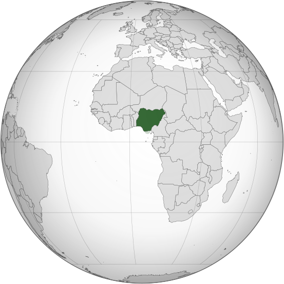
English: Orthographic map of Nigeria |
| Date | |
| Source | Own work |
| Author | Ukabia |
| Other versions |
.svg) |
.svg)
.svg)
.svg)
.svg)
.svg)
.svg)
.svg)
.svg)
.svg)
.svg)
.svg)
.svg)
.svg)
.svg)
.svg)
.svg)
.svg)
.svg)
.svg)
.svg)
.svg)
.svg)
.svg)
.svg)
.svg)
.svg)
.svg)
.svg)
.svg)
.svg)
.svg)
.svg)
.svg)
.svg)
.svg)
.svg)
.svg)
.svg)
.svg)
.svg)
.svg)
.svg)
.svg)
.svg)
.svg)
.svg)
.svg)
.svg)
.svg)
.svg)
.svg)
.svg)
.svg)
.svg)
.svg)
.svg)
.svg)
.svg)
.svg)
.svg)
.svg)
.svg)
.svg)
.svg)
.svg)
.svg)
.svg)
.svg)
.svg)
.svg)
.svg)
.svg)
.svg)

.svg)

.svg)

.svg)
.svg)
.svg)
.svg)
.svg)
.svg)
.svg)


.svg)
.svg)
.svg)
.svg)
.svg)
.svg)
.svg)

.svg)
.svg)
.svg)
.svg)
.svg)
.svg)
.svg)
.svg)
.svg)

.svg)
.svg)
.svg)
.svg)
.svg)
.svg)
.svg)
_without_national_boundaries.svg)
.svg)
.svg)
.svg)
.svg)
.svg)
.svg)

.svg)
.svg)
.png)
.svg)
.svg)
.svg)
.svg)

.svg)
.svg)
.svg)
.svg)
.svg)
.svg)
.svg)
.svg)
.svg)
.svg)
.svg)

.svg)
.svg)
.svg)
.svg)
.svg)
.svg)
.svg)
.svg)
.svg)

.svg)
.svg)

.svg)
.svg)
.svg)
.svg)
.svg)
.svg)
.svg)
.svg)
.svg)
.svg)
.svg)
.svg)
.svg)
.svg)
.svg)
.svg)
.svg)
.svg)
.svg)
.svg)
.svg)
.svg)
.svg)
.svg)
.svg)
.svg)
.svg)
_-_Crimea_disputed.svg)
.svg)
.svg)
.svg)
.svg)
.svg)
.svg)
.svg)
.svg)
.svg)
.svg)
.svg)
_political.svg)
.svg)
.svg)
.svg)
.svg)
_-_Crimea_disputed_-_no_borders.svg)
.svg)
.svg)
.svg)
.svg)
.svg)
.svg)
.svg)
.svg)
.svg)
.svg)
.svg)

.svg)
.svg)
.svg)

.png)
.svg)
.svg)
.svg)
.svg)
.svg)
.svg)
.svg)
.svg)
.svg)
.svg)
.svg)
.svg)
.svg)
.svg)
.svg)
.svg)
.svg)
.svg)
.svg)
.svg)
.svg)
.svg)
.svg)
.svg)
.svg)
.svg)
.svg)
.svg)
.svg)
.svg)
.svg)
.svg)
.svg)
.svg)
.png)
.svg)
.svg)
.svg)
_(orthographic_projection).png)
.svg)
W3C-validity not checked.
Licensing
I, the copyright holder of this work, hereby publish it under the following licenses:
This file is licensed under the Creative Commons Attribution-Share Alike 3.0 Unported license.
- You are free:
- to share – to copy, distribute and transmit the work
- to remix – to adapt the work
- Under the following conditions:
- attribution – You must give appropriate credit, provide a link to the license, and indicate if changes were made. You may do so in any reasonable manner, but not in any way that suggests the licensor endorses you or your use.
- share alike – If you remix, transform, or build upon the material, you must distribute your contributions under the same or compatible license as the original.

|
Permission is granted to copy, distribute and/or modify this document under the terms of the GNU Free Documentation License, Version 1.2 or any later version published by the Free Software Foundation; with no Invariant Sections, no Front-Cover Texts, and no Back-Cover Texts. A copy of the license is included in the section entitled GNU Free Documentation License. |
You may select the license of your choice.
File history
Click on a date/time to view the file as it appeared at that time.
| Date/Time | Thumbnail | Dimensions | User | Comment | |
|---|---|---|---|---|---|
| current | 23:52, 16 March 2015 | | 553 × 553 (218 KB) | Flappiefh | Removed Somaliland and Kosovo. Separated Western Sahara and Morroco. |
| 17:49, 30 July 2013 |  | 553 × 553 (217 KB) | Flappiefh | South Sudan added. Map made with gringer's Perlshaper tool. | |
| 04:53, 1 July 2013 |  | 550 × 550 (183 KB) | Citypeek | Valid SVG now. | |
| 19:20, 20 February 2010 |  | 550 × 550 (144 KB) | Ukabia | Changed the grey globe to gradient (Please fix to match all other orthographic project gradients if you can) and removed transparency. | |
| 19:06, 20 February 2010 |  | 550 × 550 (144 KB) | Ukabia | Transparency removed | |
| 19:03, 20 February 2010 |  | 550 × 550 (143 KB) | Ukabia | Changed the grey globe to gradient (Please fix to match all other orthographic project gradients if you can) | |
| 18:27, 20 February 2010 |  | 550 × 550 (144 KB) | Ukabia | {{Information |Description={{en|1=Orthographic map of Africa}} |Source=*File:Africa_(orthographic_projection).svg |Date=2010-02-20 18:27 (UTC) |Author=*File:Africa_(orthographic_projection).svg: Martin23230 *derivative wor |
.svg)
File usage
The following pages on the English Wikipedia use this file (pages on other projects are not listed):
- Association of Nigerian Authors
- Federation of Nigeria
- First Nigerian Republic
- History of the Jews in Nigeria
- LGBT rights in Nigeria
- List of companies of Nigeria
- Military dictatorship in Nigeria
- Nigeria
- Second Nigerian Republic
- Squatting in Nigeria
- Portal:Nigeria
- Portal:Nigeria/Intro
- Portal:Nigeria/Selected article
- Portal:Nigeria/Selected article/33
Global file usage
The following other wikis use this file:
- Usage on ady.wikipedia.org
- Usage on ami.wikipedia.org
- Usage on ar.wikipedia.org
- نيجيريا
- بوابة:العالم الإسلامي/دولة مختارة/54
- معاملة المثليين في نيجيريا
- مستخدم:جار الله/قائمة صور مقالات العلاقات الثنائية
- العلاقات الأمريكية النيجيرية
- العلاقات الأنغولية النيجيرية
- العلاقات الكورية الجنوبية النيجيرية
- العلاقات الإريترية النيجيرية
- العلاقات السويسرية النيجيرية
- العلاقات الألمانية النيجيرية
- العلاقات الليختنشتانية النيجيرية
- العلاقات البوليفية النيجيرية
- العلاقات الموزمبيقية النيجيرية
- العلاقات الألبانية النيجيرية
- العلاقات البلجيكية النيجيرية
- العلاقات الإثيوبية النيجيرية
- العلاقات البيلاروسية النيجيرية
- العلاقات الطاجيكستانية النيجيرية
- العلاقات الروسية النيجيرية
- العلاقات الرومانية النيجيرية
- العلاقات الأرجنتينية النيجيرية
- العلاقات الغامبية النيجيرية
- العلاقات القبرصية النيجيرية
- العلاقات السيراليونية النيجيرية
- العلاقات النيبالية النيجيرية
- العلاقات الليبيرية النيجيرية
- العلاقات التشيكية النيجيرية
- العلاقات الميانمارية النيجيرية
- العلاقات الكندية النيجيرية
- العلاقات العراقية النيجيرية
- العلاقات البريطانية النيجيرية
- العلاقات الكوبية النيجيرية
- العلاقات الكورية الشمالية النيجيرية
- العلاقات الكوستاريكية النيجيرية
- العلاقات الكولومبية النيجيرية
- العلاقات الكيريباتية النيجيرية
- العلاقات الكينية النيجيرية
- العلاقات اللاتفية النيجيرية
- العلاقات اللاوسية النيجيرية
- العلاقات اللبنانية النيجيرية
- العلاقات اللوكسمبورغية النيجيرية
- العلاقات الليبية النيجيرية
- العلاقات الليتوانية النيجيرية
- العلاقات الليسوتوية النيجيرية
- العلاقات المالاوية النيجيرية
- العلاقات المالطية النيجيرية
- العلاقات المالية النيجيرية
- العلاقات الماليزية النيجيرية
View more global usage of this file.
.svg)
.svg)