
File:Map of Tennessee highlighting Former State of Franklin.png
Size of this preview: 800 × 196 pixels. Other resolutions: 320 × 78 pixels | 1,024 × 251 pixels.
Original file (1,024 × 251 pixels, file size: 84 KB, MIME type: image/png)
| This is a file from the Wikimedia Commons. Information from its description page there is shown below. Commons is a freely licensed media file repository. You can help. |
| Description |
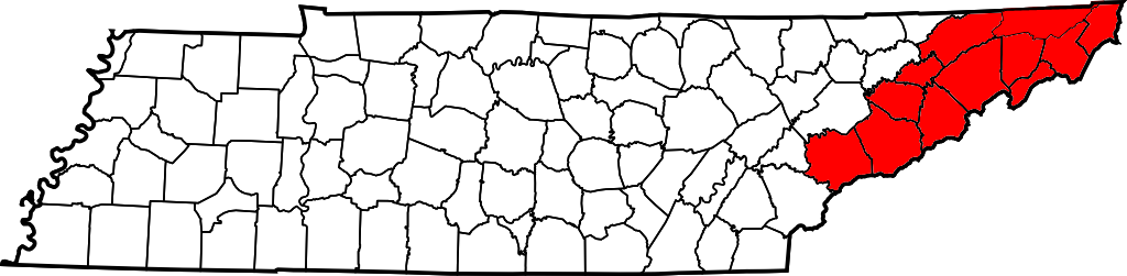
The State of Franklin (1784-1790) over a county map of Tennessee. State of Franklin was composed of the modern Tennessee counties of:
|
||||||||
| Date | |||||||||
| Source | I, Esemono, drew this map myself. | ||||||||
| Author | Iamvered | ||||||||
| Permission (Reusing this file) |
I, the copyright holder of this work, hereby publish it under the following license:
|
||||||||
| Other versions |
|


|
This proposed entity map image could be re-created using vector graphics as an SVG file. This has several advantages; see Commons:Media for cleanup for more information. If an SVG form of this image is available, please upload it and afterwards replace this template with
{{vector version available|new image name}}.
It is recommended to name the SVG file “Map of Tennessee highlighting Former State of Franklin.svg”—then the template Vector version available (or Vva) does not need the new image name parameter. |
File history
Click on a date/time to view the file as it appeared at that time.
| Date/Time | Thumbnail | Dimensions | User | Comment | |
|---|---|---|---|---|---|
| current | 03:43, 13 April 2008 | 1,024 × 251 (84 KB) | Esemono | fix borders | |
| 03:35, 13 April 2008 | 1,024 × 251 (83 KB) | Esemono | {{Information |Description=The State of Franklin (1784-1790) over a county map of Tennessee. State of Franklin was composed of the modern Tennessee counties of: *Blount County, Tennessee *[[ |
File usage
The following pages on the English Wikipedia use this file (pages on other projects are not listed):
Global file usage
The following other wikis use this file:
- Usage on ca.wikipedia.org
- Usage on de.wikipedia.org
- Usage on es.wikipedia.org
- Usage on fr.wikipedia.org
- Usage on ja.wikipedia.org
- Usage on lt.wikipedia.org
- Usage on simple.wikipedia.org
- Usage on www.wikidata.org