Castro Adobe
Jose Joaquin Castro Adobe | |
California Historical Landmark No. 998 | |
 | |
| Nearest city | Watsonville, California |
|---|---|
| Coordinates | 36°56′46″N 121°48′40″W / 36.94611°N 121.81111°W |
| Area | less than one acre |
| Built | 1848–1849 |
| Architect | José Joaquín Castro |
| Architectural style | Monterey Colonial |
| NRHP reference No. | 76000531[1] |
| CHISL No. | 998 |
| Added to NRHP | December 12, 1976 |
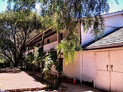
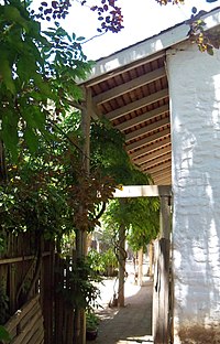
The Rancho San Andrés Castro Adobe is a historically and architecturally significant house located in the Pájaro Valley, California. The two-story Rancho San Andrés Castro Adobe is a historic rancho hacienda that was built between 1848 and 1849.[2]
History[edit]

The house was built in 1848–1849 by Juan José Castro. His father Jose Joaquin Castro (1768–1838), came to California as a 6-year-old with his family from Sinaloa Mexico on the 1775–1776 Anza Expedition. Jose Joaquín Castro received this Mexican land grant Rancho San Andrés in the area of present-day Watsonville, California. It had the first dance floor (fandango room) in Santa Cruz County, California and one of the first indoor kitchens (cocina). It is the only two-story hacienda ever built in Santa Cruz County.[3]
The house was added to the National Register of Historic Places listings in Santa Cruz County, California on December 12, 1976.[1] It is California Historical Landmark number 998.[4] The adobe was severely damaged in the 1989 Loma Prieta earthquake. One wall had completely collapsed, and the house needed seismic retrofitting before being safe for the public. Owner Edna Kimbro sold it to the state of California in 2002. Starting in August 2007, Friends of California State Parks volunteers and the California Conservation Corps began restoration by making 2500 adobe bricks.[5]
Almost 100 members of the Castro family held a reunion at the site in 2008.[6] As of September 2015[update] it was not yet opened to the public as a state park, but it is expected to open in 2016 as Rancho San Andres Castro Adobe Historic State Park.[7][needs update]

References[edit]
- ^ a b "National Register Information System". National Register of Historic Places. National Park Service. March 13, 2009.
- ^ "Rancho San Andrés Castro Adobe". California Department of Parks and Recreation. Retrieved 7 July 2022.
- ^ Todd Guild (January 16, 2010). "Castro Adobe taking shape". Watsonville Register-Pajaronian. Archived from the original on July 15, 2011. Retrieved May 22, 2010.
- ^ "California Historical Landmark: Santa Cruz County". Office of Historic Preservation. California State Parks. Retrieved 2012-10-14.
- ^ Todd Guild (August 31, 2007). "Volunteers make 2,500 bricks from dirt, water and straw for Castro Adobe". Watsonville Register-Pajaronian. Archived from the original on July 15, 2011. Retrieved May 22, 2010.
- ^ Tarmo Hannula (October 13, 2008). "Castros reunite at historic adobe home". Watsonville Register-Pajaronian. Archived from the original on June 14, 2015. Retrieved June 4, 2015.
- ^ "Castro Adobe Park Property". California State Parks Official web site. Archived from the original on September 26, 2011. Retrieved September 4, 2011.
External links[edit]
- Office of Historic Preservation — entry #998
- Friends of Santa Cruz State Parks — website on the Castro Adobe
- Chronicling the Castro Adobe — a restoration blog
- History of Santa Cruz County, California
- Adobe buildings and structures in California
- Houses on the National Register of Historic Places in California
- Houses on the National Register of Historic Places in Santa Cruz County, California
- Houses in Santa Cruz County, California
- Proposed museums in the United States
- National Register of Historic Places in Santa Cruz County, California
- Monterey Bay Area Registered Historic Place stubs


