
Blue Rock State Park
| Blue Rock State Park | |
|---|---|
 Entrance sign | |
 Blue Rock State Park Location in Ohio  Blue Rock State Park Blue Rock State Park (the United States) | |
| Location | Muskingum County, Ohio, United States |
| Coordinates | 39°48′59″N 81°50′50″W / 39.81639°N 81.84722°W[1] |
| Area | 322 acres (130 ha) |
| Elevation | 840 ft (260 m)[1] |
| Established | 1949 |
| Administered by | Ohio Department of Natural Resources |
| Designation | Ohio state park |
| Website | Blue Rock State Park |
Blue Rock State Park is a public recreation area located 11 miles (18 km) southeast of Zanesville in Muskingum County, Ohio. The state park encompasses 322 acres (130 ha) that are surrounded by the 4,573 acres (1,851 ha) of Blue Rock State Forest.[2]
History[edit]
The state's purchase of the state forest began in 1936; the dam creating Cutler Lake was finished in 1938; the state park was officially created with the advent of the Division of Parks and Recreation in 1949.[2]
Facilities and activities[edit]
The park offers swimming, boating and fishing on Cutler Lake, camping, nature trails, picnicking facilities, and hunting in the surrounding state forest.[2]
Gallery[edit]
-
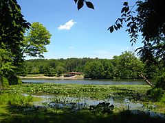 Public beach area viewed from across Cutler Lake
 -
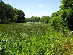 Marsh area at the east end of Cutler Lake


References[edit]
- ^ a b "Blue Rock State Park". Geographic Names Information System. United States Geological Survey, United States Department of the Interior.
- ^ a b c "Blue Rock State Park". Ohio Department of Natural Resources. Retrieved November 10, 2020.
External links[edit]
Wikimedia Commons has media related to Blue Rock State Park.
Wikivoyage has a travel guide for Ohio State
Parks that includes
Blue Rock State Park.
Parks that includes
Blue Rock State Park.
- Blue Rock State Park Ohio Department of Natural Resources
- Blue Rock State Park Map Ohio Department of Natural Resources