
Bergün Filisur
Bergün Filisur | |
|---|---|
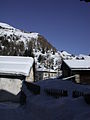
 View of Filisur looking southeast, upwards towards the Albula Pass | |
 Flag  Coat of arms | |
Location of Bergün Filisur  | |
 Bergün Filisur  Bergün Filisur | |
| Coordinates: 46°40′N 9°41′E / 46.667°N 9.683°E | |
| Country | Switzerland |
| Canton | Graubünden |
| District | Albula |
| Area | |
| • Total | 190.14 km2 (73.41 sq mi) |
| Population (31 December 2018)[1] | |
| • Total | 905 |
| • Density | 4.8/km2 (12/sq mi) |
| Time zone | UTC+01:00 (Central European Time) |
| • Summer (DST) | UTC+02:00 (Central European Summer Time) |
| Postal code(s) | 7477, 82 |
| SFOS number | 3544 |
| ISO 3166 code | CH-GR |
| Surrounded by | Alvaneu, Savognin, Schmitten, Tiefencastel, Tinizong-Rona, Davos |
| Website | https://www.berguenfilisur.ch/ SFSO statistics |
Bergün Filisur is a municipality in the Albula Region in the canton of Graubünden in Switzerland. On 1 January 2018 the former municipalities of Bergün/Bravuogn and Filisur merged to form the new municipality of Bergün Filisur.[2]
History[edit]
Bergün[edit]
Bergün/Bravuogn is first mentioned in 1209 as de Bregonio.[3]
Filisur[edit]
Filisur is first mentioned in 1262 as villa Fallisour.[4]
Geography[edit]

After the merger, Bergün Filisur has an area, as of 2009[update], of 190.14 km2 (73.41 sq mi).[5]
Population[edit]
The new municipality has a population (as of December 2020[update]) of 7,050.[6]
Historic Population[edit]
The historical population is given in the following chart. During construction of the Rhaetian Railway line the population of both communities increased significantly. [7]

Weather[edit]
Filisur has an average of 107.7 days of precipitation per year and on average receives 915 mm (36.0 in) of it. The wettest month is August during which time Filisur receives an average of 123 mm (4.8 in) of precipitation. During this month there is precipitation for an average of 11.7 days. The driest month of the year is February with an average of 40.4 mm (1.59 in) of precipitation over 6.5 days.[8]
Heritage sites of national significance[edit]
The municipal church and the Chasa Jenatsch with its barn in Bergün and the castle ruins of Greifenstein and the Schmittentobel-Landwasser Viaduct of the Rhaetian Railway in Filisur are listed as Swiss heritage sites of national significance. The villages and hamlets of Bravuogn, Latsch, Stugl and Filisur are part of the Inventory of Swiss Heritage Sites.[9]
The Albula Railway became a UNESCO World Heritage Site itself in 2008. It maintains the Bahnmuseum Albula at the Bergün train station. This railway museum documents the construction of the Albula line. Both former municipalities contain track of the Albula Railway
-
 Bergün village church
 -
 Chasa Jenatsch and barn
 -
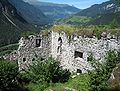 Ruins of Greifenstein Castle
 -
 Landwasser Viaduct, 65 m (213 ft) high and 136 m (446 ft) long, built in 1902


Transportation[edit]
The municipality has three railway stations: Preda, Bergün/Bravuogn, and Filisur. All three are located on the Albula line with regular service to St. Moritz and Chur. Filisur, at the junction with the Davos Platz–Filisur line, also has regular service to Davos Platz.
References[edit]
- ^ "Ständige Wohnbevölkerung nach Staatsangehörigkeitskategorie Geschlecht und Gemeinde; Provisorische Jahresergebnisse; 2018". Federal Statistical Office. 9 April 2019. Retrieved 11 April 2019.
- ^ Amtliches Gemeindeverzeichnis der Schweiz published by the Swiss Federal Statistical Office (in German) accessed 14 February 2018
- ^ Bergün/Bravuogn in German, French and Italian in the online Historical Dictionary of Switzerland.
- ^ Filisur in German, French and Italian in the online Historical Dictionary of Switzerland.
- ^ Arealstatistik Standard - Gemeindedaten nach 4 Hauptbereichen
- ^ "Ständige und nichtständige Wohnbevölkerung nach institutionellen Gliederungen, Geburtsort und Staatsangehörigkeit". bfs.admin.ch (in German). Swiss Federal Statistical Office - STAT-TAB. 31 December 2020. Retrieved 21 September 2021.
- ^ Swiss Federal Statistical Office STAT-TAB Bevölkerungsentwicklung nach institutionellen Gliederungen, 1850-2000 (in German) accessed 27 April 2016
- ^ "Temperature and Precipitation Average Values-Table, 1981-2010" (in German, French, and Italian). Federal Office of Meteorology and Climatology - MeteoSwiss. Retrieved 14 February 2018., the weather station elevation is 1030 meters above sea level.
- ^ "Swiss inventory of cultural property of national and regional significance". A-Objects. Federal Office for Cultural Protection (BABS). 1 January 2017. Archived from the original on 28 June 2010. Retrieved 6 September 2017.
External links[edit]
- Bergün/Bravuogn in Romansh, German, French and Italian in the online Historical Dictionary of Switzerland.
- Filisur in German, French and Italian in the online Historical Dictionary of Switzerland.
| International | |
|---|---|
| National | |
| Other | |