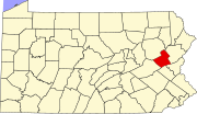
Aquashicola, Pennsylvania
Aquashicola, Pennsylvania | |
|---|---|
Unincorporated community | |
 Westbound along Little Gap Road | |
| Coordinates: 40°48′40″N 75°35′25″W / 40.81111°N 75.59028°W | |
| Country | United States |
| State | Pennsylvania |
| County | Carbon |
| Township | Lower Towamensing |
| Elevation | 413 ft (126 m) |
| Time zone | UTC-5 (Eastern (EST)) |
| • Summer (DST) | UTC-4 (EDT) |
| ZIP code | 18012 |
| Area codes | 610 and 484 |
| GNIS feature ID | 1168357[1] |
Aquashicola (locally pronounced ack-wa-SHIK-la) is an unincorporated community located in Lower Towamensing Township in Carbon County, Pennsylvania. Aquashicola is located at the intersection of Little Gap Road and Forest Inn Road north of the Aquashicola Creek and immediately east of Palmerton.[2]
History[edit]
This section contains too many or overly lengthy quotations. (August 2023) |
"Aquashicola is an Indian word that means 'Where we fish with the bush nets.' Postal service employees changed the name from Millport to Aquashicola to distinguish it from another Millport in Potter County." "The village was the site of a grist-mill, established in 1806 by George Ziegenfuss Sr. It...remained in use until 1930." "In 1830, a tannery was built along Aquashicola Creek." "The tannery was destroyed by fire in 1874. In 1844, an Evangelical Church was organized. In 1866, the United Methodist Church was formed."[3]
References[edit]
- ^ "Aquashicola". Geographic Names Information System. United States Geological Survey, United States Department of the Interior.
- ^ Carbon County, Pennsylvania Highway Map (PDF) (Map). PennDOT. 2015. Retrieved November 18, 2015.
- ^ The Morning Call, Allentown, PA, September 21, 2000, Page 85


