
Alamut

| Part of a series on Islam Isma'ilism |
|---|
 |
|
|
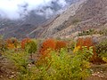
Alamut (Persian: الموت) or Rudbar (Persian: رودبار) is a region in Iran including western and eastern parts on the western edge of the Alborz (Elburz) range, between the dry and barren plain of Qazvin in the south and the densely forested slopes of the Mazandaran province in the north. Starting from Qazvin toward Alamut, passing through the first range of hills, curvatures, forms, are significant themes in nature's composition of this area. The famous Ismaili castle of Alamut and numerous others are in this area, which served as the heartland of the state founded by Hassan-i Sabbah.[1]
According to some sources, the majority of people in northern Qazvin (Alamut) are Tats who speak a dialect of the Tati language.[2][3][4][5][6][7] However, other sources claim that the majority of people in Alamut are Mazanderani[8][9] or Gilaks who speak a dialect of the Mazanderani language or Gilaki language.[10][11] According to some linguists, the term ‘Tati’ was used by Turkic speakers to refer to non-turkic speakers.[12][13][14] This could explain why some sources claim the people of Alamut are Tats, while others claim they are Mazanderanies or Gilaks. Likely, the ‘Tats’ of Alamut are Mazanderani[15] or Gilak speakers who have been labeled as Tats as historically they were considered Mazanderani or Gilaks.[16][17][18]
Name[edit]
Alamut (Persian: الموت),[19] historically known as Rudbar (رودبار) or Rudbar of Alamut (رودبار الموت Rūdbār-i Alamūt), named after the Shahrud river.
More precisely, Alamut is a small region in the historical Rudbar in which the namesake castle is located.[20]
History[edit]

In 1090 CE, Hassan-i Sabbah, the Arab founder and leader of the Assassins, a sect of Nizari Ismailis in Iran, chose the Alamut region as his headquarters to campaign, preach and convert new followers. This proved to be a turning point for the destiny of Alamut Valley. The result of over two centuries of Ismailite stronghold, the region witnessed numerous castles throughout, of which at least 20 "castles" dating back to this era have been identified. The most magnificent castle in the Alamut Valley is the Alamut Castle, which is built on top of a high rock reaching 2163 m above sea level near the Gazor Khan Village. The rock is 200 m high and covers an area of 20 hectares (49 acres); with its steep slope and deep and dangerous ravine, the rock is practically inaccessible and forms a part of the fort’s structure. Currently, only ruins of the fort and some towers are apparent, and it is only through archaeological excavation that the main portions can be discovered.[21]
Lords of Alamut Castle who ruled the Nizārī Ismā'īlī state from Alamūt[edit]
| The President of Nizārī Ismā'īlī state | Period | Master of Alamūt |
| The First Da'i Hasan bin Sabbah | 1090-1124 | 1. Effendi/Lord |
| The Second Da'i Kiya Buzurg-Ummid | 1124-1138 | 2. Effendi/Lord |
| The Third Da'i Muḥammad ibn Kiyā Buzurg-Ummīd | 1138-1162 | 3. Effendi/Lord |
| 23rd Imām Hasan ‘Alā Dhīkr‘īhī’s-Salām | 1162-1166 | 4. Effendi/Lord |
| 24th Imām Nūr al-Dīn Muhammad | 1166-1210 | 5. Effendi/Lord |
| 25th Imām Jalāl al-Dīn Hasan | 1210-1221 | 6. Effendi/Lord |
| 26th Imām ‘Alā’a-d-Dīn Muḥammad III | 1221-1255 | 7. Effendi/Lord |
| 27th Imām Rukn al-Din Khurshah | 1255-1256 | The state ended |
Today, the leader of the contemporary Ismaili community is the Aga Khan.
-
-

-
 Alamut fortification in Iran and Ismailites Assassins stronghold


Alamut rulers[edit]

- Hassan-i Sabbah
- Kia Bozorg Omid
- Muḥammad ibn Kiyā Buzurg-Ummīd
- Ali al-Hadi ibn Nizar
- Al-Muhtadi (Nizari imam)
- Al-Qahir (Imam)
- Hasan Alâ Zikrihi’s Selâm
- Nūr al-Dīn Muḥammad II
- Jalaluddin Hasan
- ‘Alā’ ad-Dīn Muḥammad III
- Ruknu-d-Dīn Khurshāh (The last ruler of the Alamut Castle)
See also[edit]
- Alamut River
- List of Ismaili castles
- Alamut-e Gharbi District
- Alamut-e Sharqi District
- Alamut-e Bala Rural District
- Alamut-e Pain Rural District
- (in Turkish) Kıyâmet-i Kûbrâ
- Alamut, novel written by Vladimir Bartol in 1938
- Alam-Kuh
References[edit]
- ^ Alamut
- ^ Maciuszak, Kinga (2012). "Some Remarks on the Northern Iranian Dialect of the Alamūt Region". Iran. 33: 111–114. doi:10.2307/4299928. JSTOR 4299928.
- ^ مقدمه کتاب «دستور زبان گویشهای تاتی جنوبی»، پروفسور احسان یارشاطر، لاهه - پاریس ١٩٦٩
- ^ گونههای زبانی تاتی، دونالد استیلو، ۱۹۸۱
- ^ مقاله «بررسی گویش تاتی الموت»، پرویز البرزی ورکی، ۱۳۷۰، دانشگاه تهران
- ^ "الموت". Archived from the original on 27 January 2016. Retrieved 16 January 2016.
- ^ "الموت من". alamouteman.com. Archived from the original on 17 July 2018. Retrieved 2018-07-17.
- ^ Jaafari Dehaghi, Mahmoud; Khalilipour, Nazanin; Jaafari Dehaghi, Shima. Iranian Languages and Dialects Past and Present. Tehran. p. 261.
- ^ Berjian, Habib. "Decreasing attention to the Mazandarian language in the 20th century". IRNA. Retrieved 19 December 2020.
- ^ "روزنامه ولایت قزوین - استان قزوین؛ گنجینه زبانهای ایرانی".
- ^ "Welcome to Encyclopaedia Iranica".
- ^ واژۀ تات را مردم ترک زبان به همسایگان غیرترک خود اطلاق می کردند. برخی تات را مترادف تازیک و تاجیک (یعنی فارسی زبان) دانسته ان دانشنامه اسلامید.
- ^ نامی که ترک ها به ایرانیان و کسانی که در سرزمین ترکان و یا سرزمین های تحت استیلای ترکان به سر می بردند... اند، فرهنگ عمید
- ^ به گروههای مختلف از اقوام غیرترک اطلاق شده:۱ - طبق قول مندرج دردیوان لغات الترک (۲۲۴) این نام نزد همه ترکان در مورد ایرانیان بکار میرفته جلال الدین مولوی هم دراشعار ترکی خود این نام را به ایرانیان اطلاق کرده.
- ^ "Considerations about the dialect of Alamut district from the northern dialects of Iran". پرتال جامع علوم انسانی.
- ^ "گیلکی زوان ٚ آمۊجش".
- ^ ألکامل، ابن اثیر
- ^ "Welcome to Encyclopaedia Iranica".
- ^ Also transliterated as Alamūt, Alemūt, Alamoot, Alemoot
- ^ B. Hourcade, “ALAMŪT,” Encyclopædia Iranica, I/8, pp. 797-801; an updated version is available online at http://www.iranicaonline.org/articles/alamut-valley-alborz-northeast-of-qazvin- (accessed on 17 May 2014).
- ^ Alamut Castle (Eagle’s Nest): Hassan Sabbah Stronghold